Kunrade geodata
Kunrade (Limburg) is a populated place; located in Netherlands in Europe/Amsterdam (GMT+2) time zone. With population of 3,405 people, there are 696 cities with bigger population in this country. Compared to other cities in Netherlands, 96.9% of cities are located further ↑North; 66.4% of cities are located further ←West and 96.7% of cities have lower elevation than Kunrade. Note1


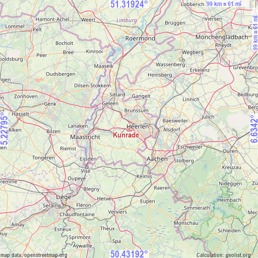
Kunrade GPS coordinates[2]
50° 52' 39.684" North, 5° 55' 51.852" East
| Map corner | latitude | longitude |
|---|---|---|
| Upper-left | 51.31924°, | 5.22795° |
| Center: | 50.87769°, | 5.93107° |
| Lower-right: | 50.43192°, | 6.6342° |
| Map W x H: | 98.7×98.7 km | = 61.3×61.3mi |
| max Lat: | 53.48025° ⇑96.9% North |
| Kunrade: | 50.87769° |
| min Lat: | ⇓3.1% South 50.76917° |
| min Long | Kunrade | max Long |
| 3.38611° | 5.93107° | 7.16528° |
| W 66.4%⇐ | ⇒33.6% E |
Elevation
Elevation of Kunrade is 93 m = 305 ft, and this is 78 m = 256 ft above average elevation for this country.
| Max E: |
203 m = 666 ft | 3.3% |
| Kunrade | 93 m 305 ft | |
| Avg. | 15 m = 49 ft | |
Min E: |
-6 m = -20 ft | 96.7% |
See also: Netherlands elevation on elevation.city.
Geographical zone
Kunrade is located in North temperate zone (between Tropic of Cancer and the Arctic Circle). Distance of this North polar circle is 1744.1 km =1083.7 mi to North.| Distance of | km | miles | from Kunrade |
|---|---|---|---|
| North Pole | 4350 | 2703 | to North |
| Arctic Circle | 1744.1 | 1083.7 | to North |
| Tropic Cancer | 3051.1 | 1895.9 | to South |
| Equator | 5657.1 | 3515.2 | to South |


Nearby cities:
15 places around Kunrade: (largest is in red/bold)
• Beersdal
3.9 km =2.4 mi,  36°
36°
• Heerlen
3.6 km =2.2 mi,  79°
79°
• Hoensbroek
5.2 km =3.2 mi,  355°
355°
• Husken
2.7 km =1.7 mi, 41°
• Klimmen
3.5 km =2.2 mi,  266°
266°
• Meezenbroek
4.7 km =2.9 mi,  62°
62°
• Nieuw-Lotbroek
3.9 km =2.4 mi, 356°
• Palemig
4.7 km =2.9 mi,  51°
51°
• Passart
5.3 km =3.3 mi,  12°
12°
• Ransdaal
3.1 km =1.9 mi,  242°
242°
• Schin op Geul
5.1 km =3.2 mi, 238°
• Termaar
3.1 km =1.9 mi,  250°
250°
• Ubachsberg
3 km =1.9 mi,  155°
155°
• Voerendaal
0.6 km =0.4 mi,  351°
351°
• Wijnandsrade
4.6 km =2.9 mi,  313°
313°
Sources, notices
• [Note1] Compared only with cities in Netherlands existing in our database
• [Src1] Map data: © OpenStreetMap contributors (CC-BY-SA)
• [Src2] Other city data from geonames.org with taken over terms of usage.
• [Src3] Geographical zone / Annual Mean Temperature by Robert A. Rohde @ Wikipedia
