Palemig geodata
Palemig (Limburg) is a section of populated place; located in Netherlands in Europe/Amsterdam (GMT+2) time zone. With population of 690 people, there are 1636 cities with bigger population in this country. Compared to other cities in Netherlands, 96.2% of cities are located further ↑North; 71.5% of cities are located further ←West and 97.3% of cities have lower elevation than Palemig. Note1


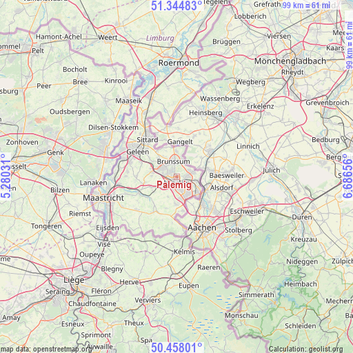
Palemig GPS coordinates[2]
50° 54' 12.708" North, 5° 59' 0.348" East
| Map corner | latitude | longitude |
|---|---|---|
| Upper-left | 51.34483°, | 5.28031° |
| Center: | 50.90353°, | 5.98343° |
| Lower-right: | 50.45801°, | 6.68656° |
| Map W x H: | 98.6×98.6 km | = 61.3×61.3mi |
| max Lat: | 53.48025° ⇑96.2% North |
| Palemig: | 50.90353° |
| min Lat: | ⇓3.8% South 50.76917° |
| min Long | Palemig | max Long |
| 3.38611° | 5.98343° | 7.16528° |
| W 71.5%⇐ | ⇒28.5% E |
Elevation
Elevation of Palemig is 105 m = 344 ft, and this is 90 m = 295 ft above average elevation for this country.
| Max E: |
203 m = 666 ft | 2.7% |
| Palemig | 105 m 344 ft | |
| Avg. | 15 m = 49 ft | |
Min E: |
-6 m = -20 ft | 97.3% |
See also: Netherlands elevation on elevation.city.
Geographical zone
Palemig is located in North temperate zone (between Tropic of Cancer and the Arctic Circle). Distance of this North polar circle is 1741.2 km =1081.9 mi to North.| Distance of | km | miles | from Palemig |
|---|---|---|---|
| North Pole | 4347.1 | 2701.2 | to North |
| Arctic Circle | 1741.2 | 1081.9 | to North |
| Tropic Cancer | 3054 | 1897.7 | to South |
| Equator | 5659.9 | 3516.9 | to South |


Nearby cities:
15 places around Palemig: (largest is in red/bold)
• Abdissenbosch
3.8 km =2.4 mi,  67°
67°
• Beersdal
1.4 km =0.9 mi,  281°
281°
• Groenstraat
4.6 km =2.9 mi,  81°
81°
• Heerlen
2.2 km =1.4 mi,  183°
183°
• Heksenberg
2 km =1.2 mi,  340°
340°
• Husken
2.1 km =1.3 mi,  245°
245°
• Kakert
1.5 km =0.9 mi,  87°
87°
• Kruisberg
4.5 km =2.8 mi, 343°
• Lauradorp
4.5 km =2.8 mi, 77°
• Lichtenberg
2.9 km =1.8 mi, 92°
• Meezenbroek
0.9 km =0.6 mi,  146°
146°
• Nieuw-Lotbroek
4 km =2.5 mi, 284°
• Passart
3.4 km =2.1 mi,  311°
311°
• Voerendaal
4.4 km =2.7 mi,  239°
239°
• Vrieheide
2.3 km =1.4 mi,  330°
330°
Sources, notices
• [Note1] Compared only with cities in Netherlands existing in our database
• [Src1] Map data: © OpenStreetMap contributors (CC-BY-SA)
• [Src2] Other city data from geonames.org with taken over terms of usage.
• [Src3] Geographical zone / Annual Mean Temperature by Robert A. Rohde @ Wikipedia
