Husken geodata
Husken (Limburg) is a populated place; located in Netherlands in Europe/Amsterdam (GMT+2) time zone. With population of 1,380 people, there are 1191 cities with bigger population in this country. Compared to other cities in Netherlands, 96.5% of cities are located further ↑North; 68.4% of cities are located further ←West and 97% of cities have lower elevation than Husken. Note1


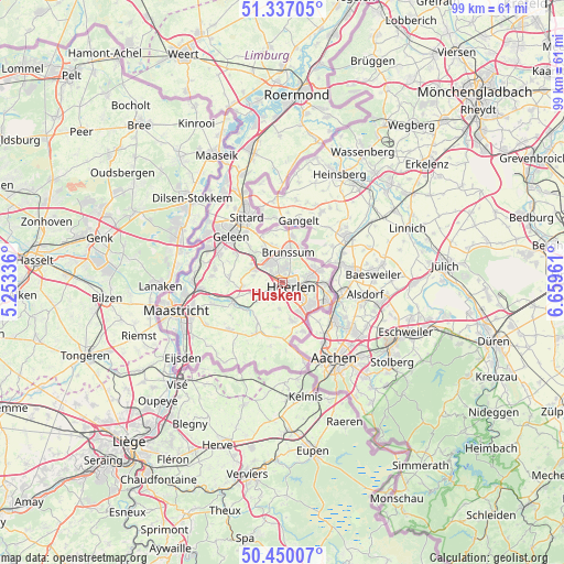
Husken GPS coordinates[2]
50° 53' 44.412" North, 5° 57' 23.328" East
| Map corner | latitude | longitude |
|---|---|---|
| Upper-left | 51.33705°, | 5.25336° |
| Center: | 50.89567°, | 5.95648° |
| Lower-right: | 50.45007°, | 6.65961° |
| Map W x H: | 98.6×98.6 km | = 61.3×61.3mi |
| max Lat: | 53.48025° ⇑96.5% North |
| Husken: | 50.89567° |
| min Lat: | ⇓3.5% South 50.76917° |
| min Long | Husken | max Long |
| 3.38611° | 5.95648° | 7.16528° |
| W 68.4%⇐ | ⇒31.6% E |
Elevation
Elevation of Husken is 100 m = 328 ft, and this is 85 m = 279 ft above average elevation for this country.
| Max E: |
203 m = 666 ft | 3% |
| Husken | 100 m 328 ft | |
| Avg. | 15 m = 49 ft | |
Min E: |
-6 m = -20 ft | 97% |
See also: Netherlands elevation on elevation.city.
Geographical zone
Husken is located in North temperate zone (between Tropic of Cancer and the Arctic Circle). Distance of this North polar circle is 1742.1 km =1082.5 mi to North.| Distance of | km | miles | from Husken |
|---|---|---|---|
| North Pole | 4348 | 2701.7 | to North |
| Arctic Circle | 1742.1 | 1082.5 | to North |
| Tropic Cancer | 3053.1 | 1897.1 | to South |
| Equator | 5659.1 | 3516.4 | to South |


Nearby cities:
15 places around Husken: (largest is in red/bold)
• Beersdal
1.3 km =0.8 mi,  25°
25°
• Heerlen
2.2 km =1.4 mi,  127°
127°
• Heksenberg
3 km =1.9 mi,  23°
23°
• Hoensbroek
3.8 km =2.4 mi,  325°
325°
• Kakert
3.5 km =2.2 mi,  74°
74°
• Kunrade
2.7 km =1.7 mi,  221°
221°
• Lichtenberg
4.9 km =3 mi,  81°
81°
• Mariarade
4.2 km =2.6 mi, 331°
• Meezenbroek
2.4 km =1.5 mi,  86°
86°
• Nieuw-Lotbroek
2.8 km =1.7 mi,  313°
313°
• Palemig
2.1 km =1.3 mi, 65°
• Passart
3.2 km =2 mi,  347°
347°
• Ubachsberg
4.7 km =2.9 mi,  186°
186°
• Voerendaal
2.3 km =1.4 mi,  233°
233°
• Vrieheide
3 km =1.9 mi,  14°
14°
Sources, notices
• [Note1] Compared only with cities in Netherlands existing in our database
• [Src1] Map data: © OpenStreetMap contributors (CC-BY-SA)
• [Src2] Other city data from geonames.org with taken over terms of usage.
• [Src3] Geographical zone / Annual Mean Temperature by Robert A. Rohde @ Wikipedia
