Naarden geodata
Naarden (North Holland) is a populated place; located in Netherlands in Europe/Amsterdam (GMT+2) time zone. With population of 17,115 people, there are 205 cities with bigger population in this country. Compared to other cities in Netherlands, 66.1% of cities are located further ↓South; 67.7% of cities are located further →East and 54.1% of cities have higher elevation than Naarden. Note1


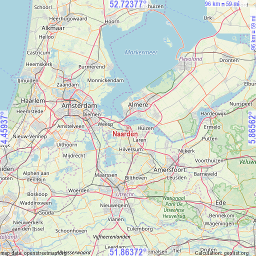
Naarden GPS coordinates[2]
52° 17' 44.988" North, 5° 9' 45" East
| Map corner | latitude | longitude |
|---|---|---|
| Upper-left | 52.72377°, | 4.45937° |
| Center: | 52.29583°, | 5.1625° |
| Lower-right: | 51.86372°, | 5.86562° |
| Map W x H: | 95.6×95.6 km | = 59.4×59.4mi |
| max Lat: | 53.48025° ⇑33.9% North |
| Naarden: | 52.29583° |
| min Lat: | ⇓66.1% South 50.76917° |
| min Long | Naarden | max Long |
| 3.38611° | 5.1625° | 7.16528° |
| W 32.3%⇐ | ⇒67.7% E |
Elevation
Elevation of Naarden is 5 m = 16 ft, and this is 10 m = 33 ft below average elevation for this country.
| Max E: |
203 m = 666 ft | 54.1% |
| Avg. | 15 m = 49 ft | |
| Naarden | 5 m = 16 ft | |
Min E: |
-6 m = -20 ft | 45.9% |
See also: Netherlands elevation on elevation.city.
Geographical zone
Naarden is located in North temperate zone (between Tropic of Cancer and the Arctic Circle). Distance of this North polar circle is 1586.4 km =985.7 mi to North.| Distance of | km | miles | from Naarden |
|---|---|---|---|
| North Pole | 4192.3 | 2605 | to North |
| Arctic Circle | 1586.4 | 985.7 | to North |
| Tropic Cancer | 3208.8 | 1993.9 | to South |
| Equator | 5814.8 | 3613.1 | to South |


Nearby cities:
15 places around Naarden: (largest is in red/bold)
• Ankeveense Rade
5.8 km =3.6 mi,  225°
225°
• Bijvanck
7.1 km =4.4 mi,  99°
99°
• Blaricum
6 km =3.7 mi,  115°
115°
• Bussum
2.5 km =1.6 mi,  182°
182°
• Eemnes
8.2 km =5.1 mi, 124°
• Hilversum
8.1 km =5 mi,  173°
173°
• Hilversumse Meent
3.2 km =2 mi,  212°
212°
• Horstermeer
7.7 km =4.8 mi, 228°
• Huizen
5.4 km =3.4 mi,  86°
86°
• Kerkelanden
8.9 km =5.5 mi,  191°
191°
• Kortenhoef
7.3 km =4.5 mi, 210°
• Laren
6.2 km =3.9 mi,  134°
134°
• Muiden
7.4 km =4.6 mi,  300°
300°
• Muiderberg
4.4 km =2.7 mi,  319°
319°
• Weesp
8.3 km =5.2 mi,  278°
278°
Sources, notices
• [Note1] Compared only with cities in Netherlands existing in our database
• [Src1] Map data: © OpenStreetMap contributors (CC-BY-SA)
• [Src2] Other city data from geonames.org with taken over terms of usage.
• [Src3] Geographical zone / Annual Mean Temperature by Robert A. Rohde @ Wikipedia
