Hilversum geodata
Hilversum (North Holland) is a populated place; located in Netherlands in Europe/Amsterdam (GMT+2) time zone. With population of 83,640 people, there are 30 cities with bigger population in this country. Compared to other cities in Netherlands, 62.6% of cities are located further ↓South; 67.2% of cities are located further →East and 52.4% of cities have lower elevation than Hilversum. Note1


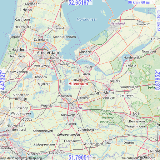
Hilversum GPS coordinates[2]
52° 13' 23.988" North, 5° 10' 35.004" East
| Map corner | latitude | longitude |
|---|---|---|
| Upper-left | 52.65197°, | 4.47327° |
| Center: | 52.22333°, | 5.17639° |
| Lower-right: | 51.79051°, | 5.87952° |
| Map W x H: | 95.8×95.8 km | = 59.5×59.5mi |
| max Lat: | 53.48025° ⇑37.4% North |
| Hilversum: | 52.22333° |
| min Lat: | ⇓62.6% South 50.76917° |
| min Long | Hilversum | max Long |
| 3.38611° | 5.17639° | 7.16528° |
| W 32.8%⇐ | ⇒67.2% E |
Elevation
Elevation of Hilversum is 7 m = 23 ft, and this is 8 m = 26 ft below average elevation for this country.
| Max E: |
203 m = 666 ft | 47.6% |
| Avg. | 15 m = 49 ft | |
| Hilversum | 7 m = 23 ft | |
Min E: |
-6 m = -20 ft | 52.4% |
See also: Hilversum elevation on elevation.city.
Geographical zone
Hilversum is located in North temperate zone (between Tropic of Cancer and the Arctic Circle). Distance of this North polar circle is 1594.5 km =990.8 mi to North.| Distance of | km | miles | from Hilversum |
|---|---|---|---|
| North Pole | 4200.4 | 2610 | to North |
| Arctic Circle | 1594.5 | 990.8 | to North |
| Tropic Cancer | 3200.8 | 1988.9 | to South |
| Equator | 5806.7 | 3608.1 | to South |


Nearby cities:
15 places around Hilversum: (largest is in red/bold)
• Ankeveense Rade
6.4 km =4 mi,  307°
307°
• Baarn
7.7 km =4.8 mi,  99°
99°
• Blaricum
7 km =4.3 mi,  39°
39°
• Bussum
5.7 km =3.5 mi,  349°
349°
• Eemnes
6.7 km =4.2 mi,  59°
59°
• Hilversumse Meent
5.9 km =3.7 mi,  333°
333°
• Hollandsche Rading
5.4 km =3.4 mi,  178°
178°
• Horstermeer
7.3 km =4.5 mi,  293°
293°
• Kerkelanden
2.8 km =1.7 mi,  256°
256°
• Kortenhoef
5 km =3.1 mi, 290°
• Laren
5.1 km =3.2 mi, 43°
• Maartensdijk
7.6 km =4.7 mi, 180°
• Naarden
8.1 km =5 mi, 353°
• Nieuw-Loosdrecht
3.7 km =2.3 mi,  223°
223°
• Oud-Loosdrecht
6.8 km =4.2 mi,  254°
254°
Sources, notices
• [Note1] Compared only with cities in Netherlands existing in our database
• [Src1] Map data: © OpenStreetMap contributors (CC-BY-SA)
• [Src2] Other city data from geonames.org with taken over terms of usage.
• [Src3] Geographical zone / Annual Mean Temperature by Robert A. Rohde @ Wikipedia
