Muiden geodata
Muiden (North Holland) is a populated place; located in Netherlands in Europe/Amsterdam (GMT+2) time zone. With population of 6,223 people, there are 399 cities with bigger population in this country. Compared to other cities in Netherlands, 67.2% of cities are located further ↓South; 71.5% of cities are located further →East and 65.8% of cities have higher elevation than Muiden. Note1


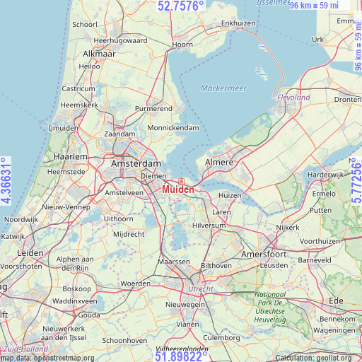
Muiden GPS coordinates[2]
52° 19' 48" North, 5° 4' 9.984" East
| Map corner | latitude | longitude |
|---|---|---|
| Upper-left | 52.7576°, | 4.36631° |
| Center: | 52.33°, | 5.06944° |
| Lower-right: | 51.89822°, | 5.77256° |
| Map W x H: | 95.6×95.6 km | = 59.4×59.4mi |
| max Lat: | 53.48025° ⇑32.8% North |
| Muiden: | 52.33° |
| min Lat: | ⇓67.2% South 50.76917° |
| min Long | Muiden | max Long |
| 3.38611° | 5.06944° | 7.16528° |
| W 28.5%⇐ | ⇒71.5% E |
Elevation
Elevation of Muiden is 3 m = 10 ft, and this is 12 m = 39 ft below average elevation for this country.
| Max E: |
203 m = 666 ft | 65.8% |
| Avg. | 15 m = 49 ft | |
| Muiden | 3 m = 10 ft | |
Min E: |
-6 m = -20 ft | 34.2% |
See also: Netherlands elevation on elevation.city.
Geographical zone
Muiden is located in North temperate zone (between Tropic of Cancer and the Arctic Circle). Distance of this North polar circle is 1582.6 km =983.4 mi to North.| Distance of | km | miles | from Muiden |
|---|---|---|---|
| North Pole | 4188.5 | 2602.6 | to North |
| Arctic Circle | 1582.6 | 983.4 | to North |
| Tropic Cancer | 3212.6 | 1996.2 | to South |
| Equator | 5818.6 | 3615.5 | to South |


Nearby cities:
15 places around Muiden: (largest is in red/bold)
• Abcoude
9.3 km =5.8 mi,  226°
226°
• Almere Stad
10.8 km =6.7 mi,  65°
65°
• Amsterdam-Zuidoost
7.1 km =4.4 mi,  249°
249°
• Ankeveense Rade
8.2 km =5.1 mi,  164°
164°
• Baambrugge
10.8 km =6.7 mi,  210°
210°
• Bussum
8.9 km =5.5 mi,  135°
135°
• Diemen
7.3 km =4.5 mi,  278°
278°
• Driemond
4.5 km =2.8 mi, 233°
• Duivendrecht
8.8 km =5.5 mi,  269°
269°
• Hilversumse Meent
8 km =5 mi, 144°
• Horstermeer
8.9 km =5.5 mi,  176°
176°
• Kortenhoef
10.4 km =6.5 mi,  165°
165°
• Muiderberg
3.5 km =2.2 mi,  97°
97°
• Naarden
7.4 km =4.6 mi,  120°
120°
• Weesp
3.1 km =1.9 mi,  217°
217°
Sources, notices
• [Note1] Compared only with cities in Netherlands existing in our database
• [Src1] Map data: © OpenStreetMap contributors (CC-BY-SA)
• [Src2] Other city data from geonames.org with taken over terms of usage.
• [Src3] Geographical zone / Annual Mean Temperature by Robert A. Rohde @ Wikipedia
