Made geodata
Made (North Brabant) is a populated place; located in Netherlands in Europe/Amsterdam (GMT+2) time zone. With population of 11,795 people, there are 259 cities with bigger population in this country. Compared to other cities in Netherlands, 70.1% of cities are located further ↑North; 80% of cities are located further →East and 65.8% of cities have higher elevation than Made. Note1


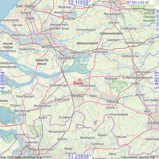
Made GPS coordinates[2]
51° 40' 36.012" North, 4° 47' 35.016" East
| Map corner | latitude | longitude |
|---|---|---|
| Upper-left | 52.11058°, | 4.08994° |
| Center: | 51.67667°, | 4.79306° |
| Lower-right: | 51.23856°, | 5.49619° |
| Map W x H: | 97×97 km | = 60.3×60.3mi |
| max Lat: | 53.48025° ⇑70.1% North |
| Made: | 51.67667° |
| min Lat: | ⇓29.9% South 50.76917° |
| min Long | Made | max Long |
| 3.38611° | 4.79306° | 7.16528° |
| W 20%⇐ | ⇒80% E |
Elevation
Elevation of Made is 3 m = 10 ft, and this is 12 m = 39 ft below average elevation for this country.
| Max E: |
203 m = 666 ft | 65.8% |
| Avg. | 15 m = 49 ft | |
| Made | 3 m = 10 ft | |
Min E: |
-6 m = -20 ft | 34.2% |
See also: Netherlands elevation on elevation.city.
Geographical zone
Made is located in North temperate zone (between Tropic of Cancer and the Arctic Circle). Distance of this North polar circle is 1655.3 km =1028.6 mi to North.| Distance of | km | miles | from Made |
|---|---|---|---|
| North Pole | 4261.2 | 2647.8 | to North |
| Arctic Circle | 1655.3 | 1028.6 | to North |
| Tropic Cancer | 3140 | 1951.1 | to South |
| Equator | 5745.9 | 3570.3 | to South |


Nearby cities:
15 places around Made: (largest is in red/bold)
• Biesdonk
7.9 km =4.9 mi,  183°
183°
• Den Hout
2.5 km =1.6 mi,  147°
147°
• Geertruidenberg
5.2 km =3.2 mi,  57°
57°
• Hoge Vucht
7.6 km =4.7 mi, 180°
• Hooge Zwaluwe
3.6 km =2.2 mi,  289°
289°
• Oosteind
8.1 km =5 mi,  116°
116°
• Oosterhout
5.8 km =3.6 mi,  127°
127°
• Raamsdonk
8 km =5 mi,  81°
81°
• Raamsdonksveer
6 km =3.7 mi,  68°
68°
• Terheijden
4.6 km =2.9 mi,  215°
215°
• Teteringen
7.7 km =4.8 mi,  165°
165°
• Wagenberg
3.3 km =2.1 mi,  247°
247°
• Waterdonken
7.5 km =4.7 mi, 173°
• Wisselaar
7.1 km =4.4 mi, 184°
• Zevenbergschen Hoek
7.9 km =4.9 mi,  266°
266°
Sources, notices
• [Note1] Compared only with cities in Netherlands existing in our database
• [Src1] Map data: © OpenStreetMap contributors (CC-BY-SA)
• [Src2] Other city data from geonames.org with taken over terms of usage.
• [Src3] Geographical zone / Annual Mean Temperature by Robert A. Rohde @ Wikipedia
