Oosteind geodata
Oosteind (North Brabant) is a populated place; located in Netherlands in Europe/Amsterdam (GMT+2) time zone. With population of 1,005 people, there are 1395 cities with bigger population in this country. Compared to other cities in Netherlands, 71.8% of cities are located further ↑North; 76.4% of cities are located further →East and 58.8% of cities have higher elevation than Oosteind. Note1


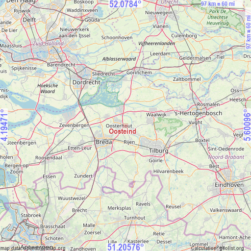
Oosteind GPS coordinates[2]
51° 38' 39.048" North, 4° 53' 52.224" East
| Map corner | latitude | longitude |
|---|---|---|
| Upper-left | 52.0784°, | 4.19471° |
| Center: | 51.64418°, | 4.89784° |
| Lower-right: | 51.20576°, | 5.60096° |
| Map W x H: | 97×97 km | = 60.3×60.3mi |
| max Lat: | 53.48025° ⇑71.8% North |
| Oosteind: | 51.64418° |
| min Lat: | ⇓28.2% South 50.76917° |
| min Long | Oosteind | max Long |
| 3.38611° | 4.89784° | 7.16528° |
| W 23.6%⇐ | ⇒76.4% E |
Elevation
Elevation of Oosteind is 4 m = 13 ft, and this is 11 m = 36 ft below average elevation for this country.
| Max E: |
203 m = 666 ft | 58.8% |
| Avg. | 15 m = 49 ft | |
| Oosteind | 4 m = 13 ft | |
Min E: |
-6 m = -20 ft | 41.2% |
See also: Netherlands elevation on elevation.city.
Geographical zone
Oosteind is located in North temperate zone (between Tropic of Cancer and the Arctic Circle). Distance of this North polar circle is 1658.9 km =1030.8 mi to North.| Distance of | km | miles | from Oosteind |
|---|---|---|---|
| North Pole | 4264.8 | 2650 | to North |
| Arctic Circle | 1658.9 | 1030.8 | to North |
| Tropic Cancer | 3136.4 | 1948.9 | to South |
| Equator | 5742.3 | 3568.1 | to South |


Nearby cities:
15 places around Oosteind: (largest is in red/bold)
• 's Gravenmoer
3.2 km =2 mi,  66°
66°
• De Moer
8.2 km =5.1 mi,  105°
105°
• Den Hout
6.1 km =3.8 mi,  284°
284°
• Dongen
3.4 km =2.1 mi,  124°
124°
• Dorst
6.7 km =4.2 mi,  205°
205°
• Geertruidenberg
7 km =4.3 mi,  336°
336°
• Made
8.1 km =5 mi,  296°
296°
• Molenschot
8 km =5 mi,  187°
187°
• Oosterhout
2.6 km =1.6 mi,  271°
271°
• Raamsdonk
4.9 km =3 mi,  8°
8°
• Raamsdonksveer
6.1 km =3.8 mi, 344°
• Rijen
6.1 km =3.8 mi,  165°
165°
• Teteringen
6.6 km =4.1 mi,  233°
233°
• Waspik
5.7 km =3.5 mi,  34°
34°
• Waterdonken
7.5 km =4.7 mi,  239°
239°
Sources, notices
• [Note1] Compared only with cities in Netherlands existing in our database
• [Src1] Map data: © OpenStreetMap contributors (CC-BY-SA)
• [Src2] Other city data from geonames.org with taken over terms of usage.
• [Src3] Geographical zone / Annual Mean Temperature by Robert A. Rohde @ Wikipedia
