Loosbroek geodata
Loosbroek (North Brabant) is a populated place; located in Netherlands in Europe/Amsterdam (GMT+2) time zone. With population of 1,295 people, there are 1242 cities with bigger population in this country. Compared to other cities in Netherlands, 70% of cities are located further ↑North; 56.3% of cities are located further →East and 55.1% of cities have lower elevation than Loosbroek. Note1


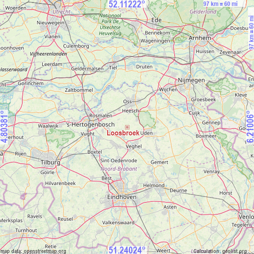
Loosbroek GPS coordinates[2]
51° 40' 41.988" North, 5° 30' 24.984" East
| Map corner | latitude | longitude |
|---|---|---|
| Upper-left | 52.11222°, | 4.80381° |
| Center: | 51.67833°, | 5.50694° |
| Lower-right: | 51.24024°, | 6.21006° |
| Map W x H: | 97×97 km | = 60.3×60.3mi |
| max Lat: | 53.48025° ⇑70% North |
| Loosbroek: | 51.67833° |
| min Lat: | ⇓30% South 50.76917° |
| min Long | Loosbroek | max Long |
| 3.38611° | 5.50694° | 7.16528° |
| W 43.7%⇐ | ⇒56.3% E |
Elevation
Elevation of Loosbroek is 8 m = 26 ft, and this is 7 m = 23 ft below average elevation for this country.
| Max E: |
203 m = 666 ft | 44.9% |
| Avg. | 15 m = 49 ft | |
| Loosbroek | 8 m = 26 ft | |
Min E: |
-6 m = -20 ft | 55.1% |
See also: Netherlands elevation on elevation.city.
Geographical zone
Loosbroek is located in North temperate zone (between Tropic of Cancer and the Arctic Circle). Distance of this North polar circle is 1655.1 km =1028.4 mi to North.| Distance of | km | miles | from Loosbroek |
|---|---|---|---|
| North Pole | 4261 | 2647.7 | to North |
| Arctic Circle | 1655.1 | 1028.4 | to North |
| Tropic Cancer | 3140.2 | 1951.2 | to South |
| Equator | 5746.1 | 3570.5 | to South |


Nearby cities:
15 places around Loosbroek: (largest is in red/bold)
• Berlicum
7.4 km =4.6 mi,  269°
269°
• Bitswijk
7.1 km =4.4 mi,  98°
98°
• Geffen
7.5 km =4.7 mi,  336°
336°
• Heesch
6.3 km =3.9 mi,  12°
12°
• Heeswijk-Dinther
3.8 km =2.4 mi,  215°
215°
• Leest
8 km =5 mi,  161°
161°
• Mariaheide
7.1 km =4.4 mi,  134°
134°
• Middelrode
6.2 km =3.9 mi,  255°
255°
• Nistelrode
4.8 km =3 mi,  53°
53°
• Schijndel
8.1 km =5 mi, 219°
• Uden
8 km =5 mi, 104°
• Veghel
7.4 km =4.6 mi, 157°
• Ven
5.2 km =3.2 mi,  145°
145°
• Vorstenbosch
4.1 km =2.5 mi, 134°
• Wijbosch
7.4 km =4.6 mi,  201°
201°
Sources, notices
• [Note1] Compared only with cities in Netherlands existing in our database
• [Src1] Map data: © OpenStreetMap contributors (CC-BY-SA)
• [Src2] Other city data from geonames.org with taken over terms of usage.
• [Src3] Geographical zone / Annual Mean Temperature by Robert A. Rohde @ Wikipedia
