Beinsdorp geodata
Beinsdorp (North Holland) is a section of populated place; located in Netherlands in Europe/Amsterdam (GMT+2) time zone. With population of 880 people, there are 1476 cities with bigger population in this country. Compared to other cities in Netherlands, 65.9% of cities are located further ↓South; 86.5% of cities are located further →East and 99.2% of cities have higher elevation than Beinsdorp. Note1


Beinsdorp GPS coordinates[2]
52° 17' 12.012" North, 4° 35' 44.988" East
| Map corner | latitude | longitude |
|---|---|---|
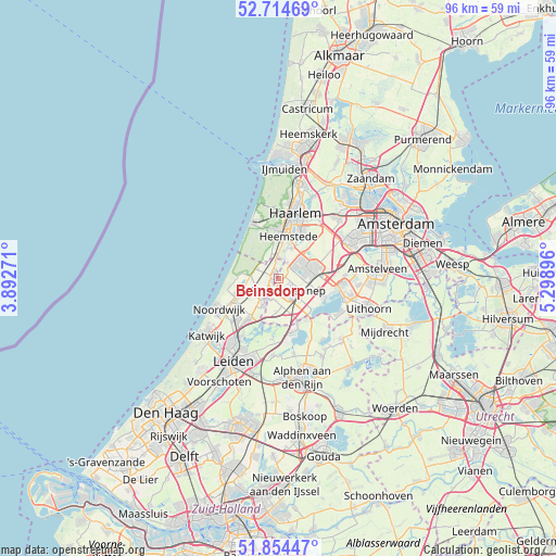
| Upper-left | 52.71469°, | 3.89271° |
| Center: | 52.28667°, | 4.59583° |
| Lower-right: | 51.85447°, | 5.29896° |
| Map W x H: | 95.6×95.6 km | = 59.4×59.4mi |
| max Lat: | 53.48025° ⇑34.1% North |
| Beinsdorp: | 52.28667° |
| min Lat: | ⇓65.9% South 50.76917° |
| min Long | Beinsdorp | max Long |
| 3.38611° | 4.59583° | 7.16528° |
| W 13.5%⇐ | ⇒86.5% E |
Elevation
Elevation of Beinsdorp is -3 m = -10 ft, and this is 18 m = 59 ft below average elevation for this country.
| Max E: |
203 m = 666 ft | 99.2% |
| Avg. | 15 m = 49 ft | |
| Beinsdorp | -3 m = -10 ft | |
Min E: |
-6 m = -20 ft | 0.8% |
See also: Netherlands elevation on elevation.city.
Geographical zone
Beinsdorp is located in North temperate zone (between Tropic of Cancer and the Arctic Circle). Distance of this North polar circle is 1587.4 km =986.4 mi to North.| Distance of | km | miles | from Beinsdorp |
|---|---|---|---|
| North Pole | 4193.3 | 2605.6 | to North |
| Arctic Circle | 1587.4 | 986.4 | to North |
| Tropic Cancer | 3207.8 | 1993.2 | to South |
| Equator | 5813.7 | 3612.5 | to South |


Nearby cities:
15 places around Beinsdorp: (largest is in red/bold)
• Abbenes
5.8 km =3.6 mi,  182°
182°
• Bennebroek
3.8 km =2.4 mi,  2°
2°
• Cruquius
6.1 km =3.8 mi,  25°
25°
• De Engel
6.4 km =4 mi,  218°
218°
• De Glip
5 km =3.1 mi,  11°
11°
• Heemstede
7.3 km =4.5 mi, 14°
• Hillegom
1 km =0.6 mi,  298°
298°
• Hoofddorp
6.6 km =4.1 mi,  74°
74°
• Lisse
4 km =2.5 mi, 221°
• Lisserbroek
3.7 km =2.3 mi,  205°
205°
• Noordwijkerhout
7.5 km =4.7 mi,  248°
248°
• Sassenheim
8.5 km =5.3 mi, 216°
• Vogelenzang
3.8 km =2.4 mi,  341°
341°
• Weerestein
2 km =1.2 mi,  345°
345°
• Zwaanshoek
3.2 km =2 mi, 26°
Sources, notices
• [Note1] Compared only with cities in Netherlands existing in our database
• [Src1] Map data: © OpenStreetMap contributors (CC-BY-SA)
• [Src2] Other city data from geonames.org with taken over terms of usage.
• [Src3] Geographical zone / Annual Mean Temperature by Robert A. Rohde @ Wikipedia
