Vogelenzang geodata
Vogelenzang (North Holland) is a populated place; located in Netherlands in Europe/Amsterdam (GMT+2) time zone. With population of 1,955 people, there are 976 cities with bigger population in this country. Compared to other cities in Netherlands, 67% of cities are located further ↓South; 87.2% of cities are located further →East and 65.8% of cities have higher elevation than Vogelenzang. Note1


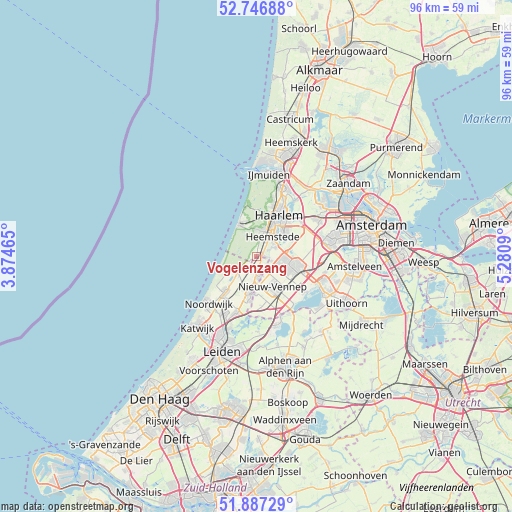
Vogelenzang GPS coordinates[2]
52° 19' 9.012" North, 4° 34' 40.008" East
| Map corner | latitude | longitude |
|---|---|---|
| Upper-left | 52.74688°, | 3.87465° |
| Center: | 52.31917°, | 4.57778° |
| Lower-right: | 51.88729°, | 5.2809° |
| Map W x H: | 95.6×95.6 km | = 59.4×59.4mi |
| max Lat: | 53.48025° ⇑33% North |
| Vogelenzang: | 52.31917° |
| min Lat: | ⇓67% South 50.76917° |
| min Long | Vogelenzang | max Long |
| 3.38611° | 4.57778° | 7.16528° |
| W 12.8%⇐ | ⇒87.2% E |
Elevation
Elevation of Vogelenzang is 3 m = 10 ft, and this is 12 m = 39 ft below average elevation for this country.
| Max E: |
203 m = 666 ft | 65.8% |
| Avg. | 15 m = 49 ft | |
| Vogelenzang | 3 m = 10 ft | |
Min E: |
-6 m = -20 ft | 34.2% |
See also: Netherlands elevation on elevation.city.
Geographical zone
Vogelenzang is located in North temperate zone (between Tropic of Cancer and the Arctic Circle). Distance of this North polar circle is 1583.8 km =984.1 mi to North.| Distance of | km | miles | from Vogelenzang |
|---|---|---|---|
| North Pole | 4189.7 | 2603.4 | to North |
| Arctic Circle | 1583.8 | 984.1 | to North |
| Tropic Cancer | 3211.4 | 1995.5 | to South |
| Equator | 5817.3 | 3614.7 | to South |


Nearby cities:
15 places around Vogelenzang: (largest is in red/bold)
• Beinsdorp
3.8 km =2.4 mi,  161°
161°
• Bennebroek
1.4 km =0.9 mi,  82°
82°
• Cruquius
4.3 km =2.7 mi,  64°
64°
• De Glip
2.6 km =1.6 mi, 60°
• Haarlem
7.9 km =4.9 mi,  30°
30°
• Heemstede
4.6 km =2.9 mi,  41°
41°
• Hillegom
3.2 km =2 mi,  173°
173°
• Hoofddorp
7.8 km =4.8 mi,  103°
103°
• Lisse
6.7 km =4.2 mi,  192°
192°
• Lisserbroek
7 km =4.3 mi,  183°
183°
• Overveen
8.4 km =5.2 mi,  16°
16°
• Vijfhuizen
7.7 km =4.8 mi, 62°
• Weerestein
1.9 km =1.2 mi, 156°
• Zandvoort
6.5 km =4 mi,  332°
332°
• Zwaanshoek
2.7 km =1.7 mi,  105°
105°
Sources, notices
• [Note1] Compared only with cities in Netherlands existing in our database
• [Src1] Map data: © OpenStreetMap contributors (CC-BY-SA)
• [Src2] Other city data from geonames.org with taken over terms of usage.
• [Src3] Geographical zone / Annual Mean Temperature by Robert A. Rohde @ Wikipedia
