Leersum geodata
Leersum (Utrecht) is a populated place; located in Netherlands in Europe/Amsterdam (GMT+2) time zone. With population of 6,385 people, there are 388 cities with bigger population in this country. Compared to other cities in Netherlands, 50.2% of cities are located further ↑North; 59.5% of cities are located further →East and 57.3% of cities have lower elevation than Leersum. Note1


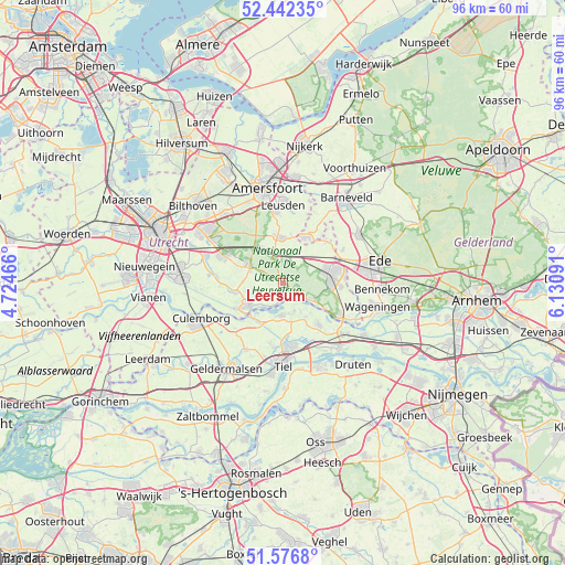
Leersum GPS coordinates[2]
52° 0' 42.012" North, 5° 25' 40.008" East
| Map corner | latitude | longitude |
|---|---|---|
| Upper-left | 52.44235°, | 4.72466° |
| Center: | 52.01167°, | 5.42778° |
| Lower-right: | 51.5768°, | 6.13091° |
| Map W x H: | 96.2×96.2 km | = 59.8×59.8mi |
| max Lat: | 53.48025° ⇑50.2% North |
| Leersum: | 52.01167° |
| min Lat: | ⇓49.8% South 50.76917° |
| min Long | Leersum | max Long |
| 3.38611° | 5.42778° | 7.16528° |
| W 40.5%⇐ | ⇒59.5% E |
Elevation
Elevation of Leersum is 9 m = 30 ft, and this is 6 m = 20 ft below average elevation for this country.
| Max E: |
203 m = 666 ft | 42.7% |
| Avg. | 15 m = 49 ft | |
| Leersum | 9 m = 30 ft | |
Min E: |
-6 m = -20 ft | 57.3% |
See also: Netherlands elevation on elevation.city.
Geographical zone
Leersum is located in North temperate zone (between Tropic of Cancer and the Arctic Circle). Distance of this North polar circle is 1618 km =1005.4 mi to North.| Distance of | km | miles | from Leersum |
|---|---|---|---|
| North Pole | 4223.9 | 2624.6 | to North |
| Arctic Circle | 1618 | 1005.4 | to North |
| Tropic Cancer | 3177.2 | 1974.2 | to South |
| Equator | 5783.2 | 3593.5 | to South |


Nearby cities:
15 places around Leersum: (largest is in red/bold)
• Amerongen
2.4 km =1.5 mi,  115°
115°
• Cothen
8.3 km =5.2 mi,  258°
258°
• Doorn
6.1 km =3.8 mi,  293°
293°
• Eck en Wiel
5.1 km =3.2 mi,  157°
157°
• Ingen
7 km =4.3 mi,  146°
146°
• Lienden
9.4 km =5.8 mi,  138°
138°
• Maarn
7 km =4.3 mi,  326°
326°
• Maarsbergen
5.4 km =3.4 mi,  343°
343°
• Maurik
5.7 km =3.5 mi,  183°
183°
• Overberg
5.5 km =3.4 mi,  55°
55°
• Renswoude
10.3 km =6.4 mi,  48°
48°
• Scherpenzeel
8.7 km =5.4 mi,  28°
28°
• Veenendaal
9.2 km =5.7 mi,  78°
78°
• Wijk bij Duurstede
7.2 km =4.5 mi,  234°
234°
• Woudenberg
7.7 km =4.8 mi,  354°
354°
Sources, notices
• [Note1] Compared only with cities in Netherlands existing in our database
• [Src1] Map data: © OpenStreetMap contributors (CC-BY-SA)
• [Src2] Other city data from geonames.org with taken over terms of usage.
• [Src3] Geographical zone / Annual Mean Temperature by Robert A. Rohde @ Wikipedia
