Kwadijk geodata
Kwadijk (North Holland) is a populated place; located in Netherlands in Europe/Amsterdam (GMT+2) time zone. With population of 760 people, there are 1561 cities with bigger population in this country. Compared to other cities in Netherlands, 72.3% of cities are located further ↓South; 73.9% of cities are located further →East and 91.3% of cities have higher elevation than Kwadijk. Note1


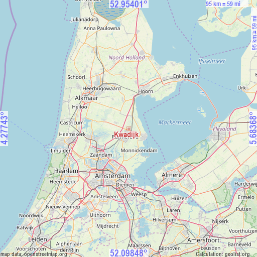
Kwadijk GPS coordinates[2]
52° 31' 41.988" North, 4° 58' 50.016" East
| Map corner | latitude | longitude |
|---|---|---|
| Upper-left | 52.95401°, | 4.27743° |
| Center: | 52.52833°, | 4.98056° |
| Lower-right: | 52.09848°, | 5.68368° |
| Map W x H: | 95.1×95.1 km | = 59.1×59.1mi |
| max Lat: | 53.48025° ⇑27.7% North |
| Kwadijk: | 52.52833° |
| min Lat: | ⇓72.3% South 50.76917° |
| min Long | Kwadijk | max Long |
| 3.38611° | 4.98056° | 7.16528° |
| W 26.1%⇐ | ⇒73.9% E |
Elevation
Elevation of Kwadijk is 0 m = 0 ft, and this is 15 m = 49 ft below average elevation for this country.
| Max E: |
203 m = 666 ft | 91.3% |
| Avg. | 15 m = 49 ft | |
| Kwadijk | 0 m = 0 ft | |
Min E: |
-6 m = -20 ft | 8.7% |
See also: Netherlands elevation on elevation.city.
Geographical zone
Kwadijk is located in North temperate zone (between Tropic of Cancer and the Arctic Circle). Distance of this North polar circle is 1560.6 km =969.7 mi to North.| Distance of | km | miles | from Kwadijk |
|---|---|---|---|
| North Pole | 4166.5 | 2588.9 | to North |
| Arctic Circle | 1560.6 | 969.7 | to North |
| Tropic Cancer | 3234.7 | 2009.9 | to South |
| Equator | 5840.6 | 3629.2 | to South |


Nearby cities:
15 places around Kwadijk: (largest is in red/bold)
• Avenhorn
10.1 km =6.3 mi,  348°
348°
• Beets
6.7 km =4.2 mi,  358°
358°
• De Rijp
9.6 km =6 mi,  289°
289°
• Den Ilp
9.6 km =6 mi,  211°
211°
• Edam
4.9 km =3 mi,  111°
111°
• Halfweg
3.6 km =2.2 mi,  262°
262°
• Ilpendam
7.5 km =4.7 mi,  195°
195°
• Middelie
2.6 km =1.6 mi,  80°
80°
• Middenbeemster
5.2 km =3.2 mi,  296°
296°
• Monnickendam
8.7 km =5.4 mi,  153°
153°
• Oosthuizen
5 km =3.1 mi,  11°
11°
• Purmerend
3 km =1.9 mi, 208°
• Schermerhorn
10.1 km =6.3 mi,  323°
323°
• Volendam
7.1 km =4.4 mi,  121°
121°
• Warder
5.1 km =3.2 mi,  37°
37°
Sources, notices
• [Note1] Compared only with cities in Netherlands existing in our database
• [Src1] Map data: © OpenStreetMap contributors (CC-BY-SA)
• [Src2] Other city data from geonames.org with taken over terms of usage.
• [Src3] Geographical zone / Annual Mean Temperature by Robert A. Rohde @ Wikipedia
