Beets geodata
Beets (North Holland) is a populated place; located in Netherlands in Europe/Amsterdam (GMT+2) time zone. With population of 525 people, there are 1804 cities with bigger population in this country. Compared to other cities in Netherlands, 73.8% of cities are located further ↓South; 74% of cities are located further →East and 91.3% of cities have higher elevation than Beets. Note1


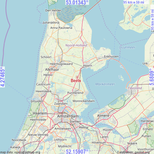
Beets GPS coordinates[2]
52° 35' 17.988" North, 4° 58' 40.008" East
| Map corner | latitude | longitude |
|---|---|---|
| Upper-left | 53.01343°, | 4.27465° |
| Center: | 52.58833°, | 4.97778° |
| Lower-right: | 52.15907°, | 5.6809° |
| Map W x H: | 95×95 km | = 59×59mi |
| max Lat: | 53.48025° ⇑26.2% North |
| Beets: | 52.58833° |
| min Lat: | ⇓73.8% South 50.76917° |
| min Long | Beets | max Long |
| 3.38611° | 4.97778° | 7.16528° |
| W 26%⇐ | ⇒74% E |
Elevation
Elevation of Beets is 0 m = 0 ft, and this is 15 m = 49 ft below average elevation for this country.
| Max E: |
203 m = 666 ft | 91.3% |
| Avg. | 15 m = 49 ft | |
| Beets | 0 m = 0 ft | |
Min E: |
-6 m = -20 ft | 8.7% |
See also: Netherlands elevation on elevation.city.
Geographical zone
Beets is located in North temperate zone (between Tropic of Cancer and the Arctic Circle). Distance of this North polar circle is 1553.9 km =965.5 mi to North.| Distance of | km | miles | from Beets |
|---|---|---|---|
| North Pole | 4159.8 | 2584.8 | to North |
| Arctic Circle | 1553.9 | 965.5 | to North |
| Tropic Cancer | 3241.4 | 2014.1 | to South |
| Equator | 5847.3 | 3633.3 | to South |


Nearby cities:
15 places around Beets: (largest is in red/bold)
• Avenhorn
3.7 km =2.3 mi,  331°
331°
• Berkhout
6.1 km =3.8 mi,  15°
15°
• De Goorn
4.7 km =2.9 mi, 333°
• De Rijp
9.6 km =6 mi,  248°
248°
• Grootschermer
8.7 km =5.4 mi,  265°
265°
• Halfweg
7.9 km =4.9 mi,  205°
205°
• Hoorn
8.2 km =5.1 mi,  42°
42°
• Kwadijk
6.7 km =4.2 mi,  178°
178°
• Middelie
6.8 km =4.2 mi,  156°
156°
• Middenbeemster
6.2 km =3.9 mi,  225°
225°
• Oosthuizen
2.1 km =1.3 mi,  145°
145°
• Purmerend
9.3 km =5.8 mi,  187°
187°
• Schermerhorn
6 km =3.7 mi,  283°
283°
• Spierdijk
7.3 km =4.5 mi,  341°
341°
• Warder
4.2 km =2.6 mi,  128°
128°
Sources, notices
• [Note1] Compared only with cities in Netherlands existing in our database
• [Src1] Map data: © OpenStreetMap contributors (CC-BY-SA)
• [Src2] Other city data from geonames.org with taken over terms of usage.
• [Src3] Geographical zone / Annual Mean Temperature by Robert A. Rohde @ Wikipedia
