Klazienaveen geodata
Klazienaveen (Drenthe) is a populated place; located in Netherlands in Europe/Amsterdam (GMT+2) time zone. With population of 11,919 people, there are 253 cities with bigger population in this country. Compared to other cities in Netherlands, 77.4% of cities are located further ↓South; 99% of cities are located further ←West and 74.9% of cities have lower elevation than Klazienaveen. Note1


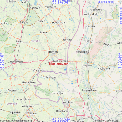
Klazienaveen GPS coordinates[2]
52° 43' 27.012" North, 6° 59' 25.008" East
| Map corner | latitude | longitude |
|---|---|---|
| Upper-left | 53.14794°, | 6.28716° |
| Center: | 52.72417°, | 6.99028° |
| Lower-right: | 52.29624°, | 7.69341° |
| Map W x H: | 94.7×94.7 km | = 58.8×58.8mi |
| max Lat: | 53.48025° ⇑22.6% North |
| Klazienaveen: | 52.72417° |
| min Lat: | ⇓77.4% South 50.76917° |
| min Long | Klazienaveen | max Long |
| 3.38611° | 6.99028° | 7.16528° |
| W 99%⇐ | ⇒1% E |
Elevation
Elevation of Klazienaveen is 18 m = 59 ft, and this is 3 m = 10 ft above average elevation for this country.
| Max E: |
203 m = 666 ft | 25.1% |
| Klazienaveen | 18 m 59 ft | |
| Avg. | 15 m = 49 ft | |
Min E: |
-6 m = -20 ft | 74.9% |
See also: Netherlands elevation on elevation.city.
Geographical zone
Klazienaveen is located in North temperate zone (between Tropic of Cancer and the Arctic Circle). Distance of this North polar circle is 1538.8 km =956.2 mi to North.| Distance of | km | miles | from Klazienaveen |
|---|---|---|---|
| North Pole | 4144.7 | 2575.4 | to North |
| Arctic Circle | 1538.8 | 956.2 | to North |
| Tropic Cancer | 3256.5 | 2023.5 | to South |
| Equator | 5862.4 | 3642.7 | to South |


Nearby cities:
15 places around Klazienaveen: (largest is in red/bold)
• Angelslo
7.6 km =4.7 mi,  325°
325°
• Barger-Oosterveld
5.5 km =3.4 mi,  337°
337°
• Bargeres
8.4 km =5.2 mi,  299°
299°
• Emmen
8.3 km =5.2 mi,  317°
317°
• Emmer-Compascuum
10.5 km =6.5 mi,  21°
21°
• Emmer-Erfscheidenveen
9.2 km =5.7 mi,  359°
359°
• Emmerhout
7.9 km =4.9 mi, 333°
• Emmermeer
10.7 km =6.6 mi, 322°
• Emmerschans
9.2 km =5.7 mi, 337°
• Nieuw-Dordrecht
3.1 km =1.9 mi, 330°
• Nieuw-Schoonebeek
8.4 km =5.2 mi,  181°
181°
• Noordbarge
8.8 km =5.5 mi,  307°
307°
• Schoonebeek
9.9 km =6.2 mi,  226°
226°
• Veenoord
9.7 km =6 mi,  261°
261°
• Weiteveen
5.7 km =3.5 mi, 181°
Sources, notices
• [Note1] Compared only with cities in Netherlands existing in our database
• [Src1] Map data: © OpenStreetMap contributors (CC-BY-SA)
• [Src2] Other city data from geonames.org with taken over terms of usage.
• [Src3] Geographical zone / Annual Mean Temperature by Robert A. Rohde @ Wikipedia
