Ketelhaven geodata
Ketelhaven (Flevoland) is a populated place; located in Netherlands in Europe/Amsterdam (GMT+2) time zone. With population of 595 people, there are 1725 cities with bigger population in this country. Compared to other cities in Netherlands, 73.4% of cities are located further ↓South; 55.2% of cities are located further ←West and 98.2% of cities have higher elevation than Ketelhaven. Note1


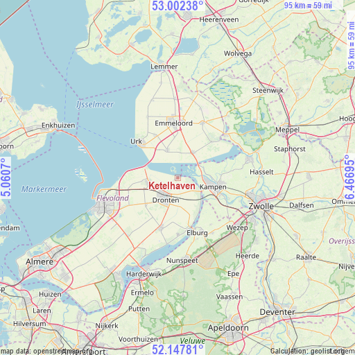
Ketelhaven GPS coordinates[2]
52° 34' 37.848" North, 5° 45' 49.788" East
| Map corner | latitude | longitude |
|---|---|---|
| Upper-left | 53.00238°, | 5.0607° |
| Center: | 52.57718°, | 5.76383° |
| Lower-right: | 52.14781°, | 6.46695° |
| Map W x H: | 95×95 km | = 59×59mi |
| max Lat: | 53.48025° ⇑26.6% North |
| Ketelhaven: | 52.57718° |
| min Lat: | ⇓73.4% South 50.76917° |
| min Long | Ketelhaven | max Long |
| 3.38611° | 5.76383° | 7.16528° |
| W 55.2%⇐ | ⇒44.8% E |
Elevation
Elevation of Ketelhaven is -2 m = -7 ft, and this is 17 m = 56 ft below average elevation for this country.
| Max E: |
203 m = 666 ft | 98.2% |
| Avg. | 15 m = 49 ft | |
| Ketelhaven | -2 m = -7 ft | |
Min E: |
-6 m = -20 ft | 1.8% |
See also: Netherlands elevation on elevation.city.
Geographical zone
Ketelhaven is located in North temperate zone (between Tropic of Cancer and the Arctic Circle). Distance of this North polar circle is 1555.1 km =966.3 mi to North.| Distance of | km | miles | from Ketelhaven |
|---|---|---|---|
| North Pole | 4161 | 2585.5 | to North |
| Arctic Circle | 1555.1 | 966.3 | to North |
| Tropic Cancer | 3240.1 | 2013.3 | to South |
| Equator | 5846 | 3632.5 | to South |


Nearby cities:
15 places around Ketelhaven: (largest is in red/bold)
• Biddinghuizen
14.4 km =8.9 mi,  199°
199°
• Brunnepe
9.6 km =6 mi,  100°
100°
• Dronten
6.6 km =4.1 mi,  208°
208°
• Elburg
15.4 km =9.6 mi,  159°
159°
• Emmeloord
14.9 km =9.3 mi,  356°
356°
• Ens
7.9 km =4.9 mi,  33°
33°
• Flevowijk
10.7 km =6.6 mi,  109°
109°
• Grafhorst
11.5 km =7.1 mi,  87°
87°
• Kampen
10.3 km =6.4 mi, 103°
• Kamperveen
13.7 km =8.5 mi,  124°
124°
• Oostendorp
15.7 km =9.8 mi, 157°
• Oosterholt
13.1 km =8.1 mi, 98°
• Oosterwolde
15.1 km =9.4 mi,  145°
145°
• Urk
14.5 km =9 mi,  310°
310°
• Wilsum
14.7 km =9.1 mi, 111°
Sources, notices
• [Note1] Compared only with cities in Netherlands existing in our database
• [Src1] Map data: © OpenStreetMap contributors (CC-BY-SA)
• [Src2] Other city data from geonames.org with taken over terms of usage.
• [Src3] Geographical zone / Annual Mean Temperature by Robert A. Rohde @ Wikipedia
