Stadbroek geodata
Stadbroek (Limburg) is a section of populated place; located in Netherlands in Europe/Amsterdam (GMT+2) time zone. With population of 2,525 people, there are 833 cities with bigger population in this country. Compared to other cities in Netherlands, 93.5% of cities are located further ↑North; 62.3% of cities are located further ←West and 92.3% of cities have lower elevation than Stadbroek. Note1


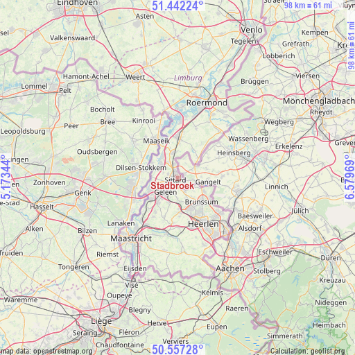
Stadbroek GPS coordinates[2]
51° 0' 6.732" North, 5° 52' 35.616" East
| Map corner | latitude | longitude |
|---|---|---|
| Upper-left | 51.44224°, | 5.17344° |
| Center: | 51.00187°, | 5.87656° |
| Lower-right: | 50.55728°, | 6.57969° |
| Map W x H: | 98.4×98.4 km | = 61.1×61.1mi |
| max Lat: | 53.48025° ⇑93.5% North |
| Stadbroek: | 51.00187° |
| min Lat: | ⇓6.5% South 50.76917° |
| min Long | Stadbroek | max Long |
| 3.38611° | 5.87656° | 7.16528° |
| W 62.3%⇐ | ⇒37.7% E |
Elevation
Elevation of Stadbroek is 42 m = 138 ft, and this is 27 m = 89 ft above average elevation for this country.
| Max E: |
203 m = 666 ft | 7.7% |
| Stadbroek | 42 m 138 ft | |
| Avg. | 15 m = 49 ft | |
Min E: |
-6 m = -20 ft | 92.3% |
See also: Netherlands elevation on elevation.city.
Geographical zone
Stadbroek is located in North temperate zone (between Tropic of Cancer and the Arctic Circle). Distance of this North polar circle is 1730.3 km =1075.2 mi to North.| Distance of | km | miles | from Stadbroek |
|---|---|---|---|
| North Pole | 4336.2 | 2694.4 | to North |
| Arctic Circle | 1730.3 | 1075.2 | to North |
| Tropic Cancer | 3065 | 1904.5 | to South |
| Equator | 5670.9 | 3523.7 | to South |


Nearby cities:
15 places around Stadbroek: (largest is in red/bold)
• Bingelrade
4.5 km =2.8 mi,  129°
129°
• Broeksittard
1.3 km =0.8 mi,  84°
84°
• Doenrade
4.4 km =2.7 mi,  150°
150°
• Einighausen
3.4 km =2.1 mi,  269°
269°
• Geleen
4.5 km =2.8 mi,  227°
227°
• Guttecoven
4.3 km =2.7 mi,  289°
289°
• Jabeek
5.1 km =3.2 mi,  117°
117°
• Limbricht
2.9 km =1.8 mi, 291°
• Lindenheuvel
4.6 km =2.9 mi,  246°
246°
• Munstergeleen
3.1 km =1.9 mi,  196°
196°
• Ophoven
1.8 km =1.1 mi,  224°
224°
• Overhoven
1 km =0.6 mi,  316°
316°
• Puth
5.3 km =3.3 mi,  182°
182°
• Sittard
0.6 km =0.4 mi, 231°
• Sweikhuizen
5.7 km =3.5 mi, 201°
Sources, notices
• [Note1] Compared only with cities in Netherlands existing in our database
• [Src1] Map data: © OpenStreetMap contributors (CC-BY-SA)
• [Src2] Other city data from geonames.org with taken over terms of usage.
• [Src3] Geographical zone / Annual Mean Temperature by Robert A. Rohde @ Wikipedia
