Baarn geodata
Baarn (Utrecht) is a populated place; located in Netherlands in Europe/Amsterdam (GMT+2) time zone. With population of 24,584 people, there are 138 cities with bigger population in this country. Compared to other cities in Netherlands, 61.3% of cities are located further ↓South; 64% of cities are located further →East and 59.4% of cities have lower elevation than Baarn. Note1


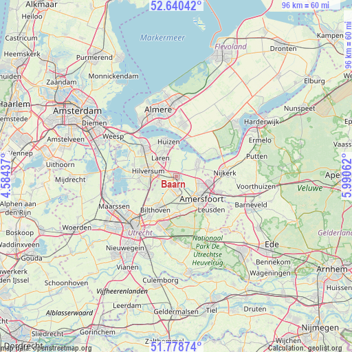
Baarn GPS coordinates[2]
52° 12' 42.012" North, 5° 17' 15" East
| Map corner | latitude | longitude |
|---|---|---|
| Upper-left | 52.64042°, | 4.58437° |
| Center: | 52.21167°, | 5.2875° |
| Lower-right: | 51.77874°, | 5.99062° |
| Map W x H: | 95.8×95.8 km | = 59.5×59.5mi |
| max Lat: | 53.48025° ⇑38.7% North |
| Baarn: | 52.21167° |
| min Lat: | ⇓61.3% South 50.76917° |
| min Long | Baarn | max Long |
| 3.38611° | 5.2875° | 7.16528° |
| W 36%⇐ | ⇒64% E |
Elevation
Elevation of Baarn is 10 m = 33 ft, and this is 5 m = 16 ft below average elevation for this country.
| Max E: |
203 m = 666 ft | 40.6% |
| Avg. | 15 m = 49 ft | |
| Baarn | 10 m = 33 ft | |
Min E: |
-6 m = -20 ft | 59.4% |
See also: Netherlands elevation on elevation.city.
Geographical zone
Baarn is located in North temperate zone (between Tropic of Cancer and the Arctic Circle). Distance of this North polar circle is 1595.8 km =991.6 mi to North.| Distance of | km | miles | from Baarn |
|---|---|---|---|
| North Pole | 4201.7 | 2610.8 | to North |
| Arctic Circle | 1595.8 | 991.6 | to North |
| Tropic Cancer | 3199.5 | 1988.1 | to South |
| Equator | 5805.4 | 3607.3 | to South |


Nearby cities:
15 places around Baarn: (largest is in red/bold)
• Amersfoort
9.3 km =5.8 mi,  132°
132°
• Bijvanck
8.4 km =5.2 mi,  349°
349°
• Blaricum
7.4 km =4.6 mi,  335°
335°
• Bunschoten
7.1 km =4.4 mi,  60°
60°
• Eemdijk
5.6 km =3.5 mi,  31°
31°
• Eemnes
5.1 km =3.2 mi, 339°
• Hilversum
7.7 km =4.8 mi,  279°
279°
• Hollandsche Rading
8.5 km =5.3 mi,  241°
241°
• Hoogland
6.7 km =4.2 mi,  118°
118°
• Langenoord
6.9 km =4.3 mi,  112°
112°
• Laren
6.4 km =4 mi,  320°
320°
• Maartensdijk
9.9 km =6.2 mi,  230°
230°
• Soest
4.3 km =2.7 mi,  176°
176°
• Soestdijk
2.3 km =1.4 mi, 184°
• Spakenburg
6.9 km =4.3 mi,  51°
51°
Sources, notices
• [Note1] Compared only with cities in Netherlands existing in our database
• [Src1] Map data: © OpenStreetMap contributors (CC-BY-SA)
• [Src2] Other city data from geonames.org with taken over terms of usage.
• [Src3] Geographical zone / Annual Mean Temperature by Robert A. Rohde @ Wikipedia
