Hemelum geodata
Hemelum (Friesland) is a populated place; located in Netherlands in Europe/Amsterdam (GMT+2) time zone. With population of 505 people, there are 1833 cities with bigger population in this country. Compared to other cities in Netherlands, 82% of cities are located further ↓South; 58.7% of cities are located further →East and 58.8% of cities have higher elevation than Hemelum. Note1


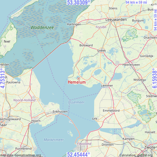
Hemelum GPS coordinates[2]
52° 52' 51.024" North, 5° 27' 22.536" East
| Map corner | latitude | longitude |
|---|---|---|
| Upper-left | 53.30309°, | 4.75313° |
| Center: | 52.88084°, | 5.45626° |
| Lower-right: | 52.45444°, | 6.15938° |
| Map W x H: | 94.4×94.4 km | = 58.7×58.7mi |
| max Lat: | 53.48025° ⇑18% North |
| Hemelum: | 52.88084° |
| min Lat: | ⇓82% South 50.76917° |
| min Long | Hemelum | max Long |
| 3.38611° | 5.45626° | 7.16528° |
| W 41.3%⇐ | ⇒58.7% E |
Elevation
Elevation of Hemelum is 4 m = 13 ft, and this is 11 m = 36 ft below average elevation for this country.
| Max E: |
203 m = 666 ft | 58.8% |
| Avg. | 15 m = 49 ft | |
| Hemelum | 4 m = 13 ft | |
Min E: |
-6 m = -20 ft | 41.2% |
See also: Netherlands elevation on elevation.city.
Geographical zone
Hemelum is located in North temperate zone (between Tropic of Cancer and the Arctic Circle). Distance of this North polar circle is 1521.4 km =945.4 mi to North.| Distance of | km | miles | from Hemelum |
|---|---|---|---|
| North Pole | 4127.3 | 2564.6 | to North |
| Arctic Circle | 1521.4 | 945.4 | to North |
| Tropic Cancer | 3273.9 | 2034.3 | to South |
| Equator | 5879.8 | 3653.5 | to South |


Nearby cities:
15 places around Hemelum: (largest is in red/bold)
• Bakhuizen
1.2 km =0.7 mi,  170°
170°
• Balk
8.5 km =5.3 mi,  77°
77°
• Blauwhuis
16.5 km =10.3 mi,  18°
18°
• Heeg
14.2 km =8.8 mi,  46°
46°
• Hindeloopen
7.8 km =4.8 mi,  331°
331°
• Koudum
3.9 km =2.4 mi,  352°
352°
• Nijemirdum
8 km =5 mi,  109°
109°
• Oudega
13.8 km =8.6 mi,  26°
26°
• Oudemirdum
6.3 km =3.9 mi,  122°
122°
• Sloten
12.8 km =8 mi, 83°
• Stavoren
6.6 km =4.1 mi,  274°
274°
• Warns
3.6 km =2.2 mi, 273°
• Wijckel
11.2 km =7 mi,  85°
85°
• Workum
11 km =6.8 mi,  356°
356°
• Woudsend
13.5 km =8.4 mi,  58°
58°
Sources, notices
• [Note1] Compared only with cities in Netherlands existing in our database
• [Src1] Map data: © OpenStreetMap contributors (CC-BY-SA)
• [Src2] Other city data from geonames.org with taken over terms of usage.
• [Src3] Geographical zone / Annual Mean Temperature by Robert A. Rohde @ Wikipedia
