Blauwhuis geodata
Blauwhuis (Friesland) is a populated place; located in Netherlands in Europe/Amsterdam (GMT+2) time zone. With population of 590 people, there are 1733 cities with bigger population in this country. Compared to other cities in Netherlands, 86.3% of cities are located further ↓South; 55.5% of cities are located further →East and 83.9% of cities have higher elevation than Blauwhuis. Note1


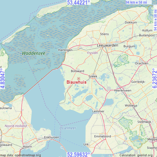
Blauwhuis GPS coordinates[2]
53° 1' 16.824" North, 5° 32' 0.924" East
| Map corner | latitude | longitude |
|---|---|---|
| Upper-left | 53.44221°, | 4.83047° |
| Center: | 53.02134°, | 5.53359° |
| Lower-right: | 52.59632°, | 6.23672° |
| Map W x H: | 94.1×94.1 km | = 58.5×58.5mi |
| max Lat: | 53.48025° ⇑13.7% North |
| Blauwhuis: | 53.02134° |
| min Lat: | ⇓86.3% South 50.76917° |
| min Long | Blauwhuis | max Long |
| 3.38611° | 5.53359° | 7.16528° |
| W 44.5%⇐ | ⇒55.5% E |
Elevation
Elevation of Blauwhuis is 1 m = 3 ft, and this is 14 m = 46 ft below average elevation for this country.
| Max E: |
203 m = 666 ft | 83.9% |
| Avg. | 15 m = 49 ft | |
| Blauwhuis | 1 m = 3 ft | |
Min E: |
-6 m = -20 ft | 16.1% |
See also: Netherlands elevation on elevation.city.
Geographical zone
Blauwhuis is located in North temperate zone (between Tropic of Cancer and the Arctic Circle). Distance of this North polar circle is 1505.8 km =935.7 mi to North.| Distance of | km | miles | from Blauwhuis |
|---|---|---|---|
| North Pole | 4111.6 | 2554.8 | to North |
| Arctic Circle | 1505.8 | 935.7 | to North |
| Tropic Cancer | 3289.5 | 2044 | to South |
| Equator | 5895.4 | 3663.2 | to South |


Nearby cities:
15 places around Blauwhuis: (largest is in red/bold)
• Bolsward
4.9 km =3 mi,  358°
358°
• De Domp
9.7 km =6 mi,  83°
83°
• Heeg
7.8 km =4.8 mi,  138°
138°
• Hommerts
9 km =5.6 mi,  120°
120°
• IJlst
6.1 km =3.8 mi,  101°
101°
• Makkum
9.5 km =5.9 mi,  292°
292°
• Nijland
4.3 km =2.7 mi,  41°
41°
• Oudega
3.4 km =2.1 mi,  162°
162°
• Sneek
8.5 km =5.3 mi, 81°
• Stadsfenne
9.9 km =6.2 mi, 77°
• Tinga
7.5 km =4.7 mi,  90°
90°
• Witmarsum
10.2 km =6.3 mi,  334°
334°
• Wommels
10.4 km =6.5 mi,  20°
20°
• Workum
7.4 km =4.6 mi,  231°
231°
• Ysbrechtum
6.9 km =4.3 mi,  71°
71°
Sources, notices
• [Note1] Compared only with cities in Netherlands existing in our database
• [Src1] Map data: © OpenStreetMap contributors (CC-BY-SA)
• [Src2] Other city data from geonames.org with taken over terms of usage.
• [Src3] Geographical zone / Annual Mean Temperature by Robert A. Rohde @ Wikipedia
