Driemond geodata
Driemond (North Holland) is a populated place; located in Netherlands in Europe/Amsterdam (GMT+2) time zone. With population of 1,500 people, there are 1130 cities with bigger population in this country. Compared to other cities in Netherlands, 66.6% of cities are located further ↓South; 73.1% of cities are located further →East and 83.9% of cities have higher elevation than Driemond. Note1


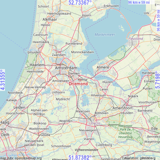
Driemond GPS coordinates[2]
52° 18' 20.988" North, 5° 1' 0.012" East
| Map corner | latitude | longitude |
|---|---|---|
| Upper-left | 52.73367°, | 4.31355° |
| Center: | 52.30583°, | 5.01667° |
| Lower-right: | 51.87382°, | 5.7198° |
| Map W x H: | 95.6×95.6 km | = 59.4×59.4mi |
| max Lat: | 53.48025° ⇑33.4% North |
| Driemond: | 52.30583° |
| min Lat: | ⇓66.6% South 50.76917° |
| min Long | Driemond | max Long |
| 3.38611° | 5.01667° | 7.16528° |
| W 26.9%⇐ | ⇒73.1% E |
Elevation
Elevation of Driemond is 1 m = 3 ft, and this is 14 m = 46 ft below average elevation for this country.
| Max E: |
203 m = 666 ft | 83.9% |
| Avg. | 15 m = 49 ft | |
| Driemond | 1 m = 3 ft | |
Min E: |
-6 m = -20 ft | 16.1% |
See also: Netherlands elevation on elevation.city.
Geographical zone
Driemond is located in North temperate zone (between Tropic of Cancer and the Arctic Circle). Distance of this North polar circle is 1585.3 km =985.1 mi to North.| Distance of | km | miles | from Driemond |
|---|---|---|---|
| North Pole | 4191.2 | 2604.3 | to North |
| Arctic Circle | 1585.3 | 985.1 | to North |
| Tropic Cancer | 3209.9 | 1994.5 | to South |
| Equator | 5815.9 | 3613.8 | to South |


Nearby cities:
15 places around Driemond: (largest is in red/bold)
• Abcoude
4.9 km =3 mi,  220°
220°
• Amstelveen
10.4 km =6.5 mi,  266°
266°
• Amsterdam-Zuidoost
3 km =1.9 mi, 273°
• Ankeveense Rade
7.8 km =4.8 mi,  132°
132°
• Baambrugge
6.9 km =4.3 mi,  195°
195°
• Diemen
5.3 km =3.3 mi,  315°
315°
• Duivendrecht
5.9 km =3.7 mi,  296°
296°
• Hilversumse Meent
9.1 km =5.7 mi,  115°
115°
• Horstermeer
7.5 km =4.7 mi,  146°
146°
• Kortenhoef
9.6 km =6 mi,  140°
140°
• Muiden
4.5 km =2.8 mi,  53°
53°
• Muiderberg
7.4 km =4.6 mi,  72°
72°
• Naarden
10 km =6.2 mi,  96°
96°
• Ouderkerk aan de Amstel
7.5 km =4.7 mi,  260°
260°
• Weesp
1.7 km =1.1 mi,  83°
83°
Sources, notices
• [Note1] Compared only with cities in Netherlands existing in our database
• [Src1] Map data: © OpenStreetMap contributors (CC-BY-SA)
• [Src2] Other city data from geonames.org with taken over terms of usage.
• [Src3] Geographical zone / Annual Mean Temperature by Robert A. Rohde @ Wikipedia
