Baambrugge geodata
Baambrugge (Utrecht) is a populated place; located in Netherlands in Europe/Amsterdam (GMT+2) time zone. With population of 1,010 people, there are 1391 cities with bigger population in this country. Compared to other cities in Netherlands, 64% of cities are located further ↓South; 73.8% of cities are located further →East and 96.1% of cities have higher elevation than Baambrugge. Note1


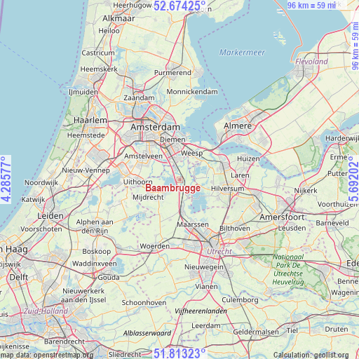
Baambrugge GPS coordinates[2]
52° 14' 44.988" North, 4° 59' 20.004" East
| Map corner | latitude | longitude |
|---|---|---|
| Upper-left | 52.67425°, | 4.28577° |
| Center: | 52.24583°, | 4.98889° |
| Lower-right: | 51.81323°, | 5.69202° |
| Map W x H: | 95.7×95.7 km | = 59.5×59.5mi |
| max Lat: | 53.48025° ⇑36% North |
| Baambrugge: | 52.24583° |
| min Lat: | ⇓64% South 50.76917° |
| min Long | Baambrugge | max Long |
| 3.38611° | 4.98889° | 7.16528° |
| W 26.2%⇐ | ⇒73.8% E |
Elevation
Elevation of Baambrugge is -1 m = -3 ft, and this is 16 m = 52 ft below average elevation for this country.
| Max E: |
203 m = 666 ft | 96.1% |
| Avg. | 15 m = 49 ft | |
| Baambrugge | -1 m = -3 ft | |
Min E: |
-6 m = -20 ft | 3.9% |
See also: Netherlands elevation on elevation.city.
Geographical zone
Baambrugge is located in North temperate zone (between Tropic of Cancer and the Arctic Circle). Distance of this North polar circle is 1592 km =989.2 mi to North.| Distance of | km | miles | from Baambrugge |
|---|---|---|---|
| North Pole | 4197.9 | 2608.5 | to North |
| Arctic Circle | 1592 | 989.2 | to North |
| Tropic Cancer | 3203.3 | 1990.4 | to South |
| Equator | 5809.2 | 3609.7 | to South |


Nearby cities:
15 places around Baambrugge: (largest is in red/bold)
• Abcoude
3.2 km =2 mi,  335°
335°
• Amsterdam-Zuidoost
7 km =4.3 mi,  350°
350°
• Ankeveense Rade
7.8 km =4.8 mi,  79°
79°
• Breukelen
8 km =5 mi,  173°
173°
• Driemond
6.9 km =4.3 mi,  15°
15°
• Duivendrecht
9.9 km =6.2 mi, 340°
• Hilversumse Meent
10.5 km =6.5 mi,  74°
74°
• Horstermeer
6.1 km =3.8 mi,  85°
85°
• Kortenhoef
8.1 km =5 mi,  95°
95°
• Mijdrecht
9.6 km =6 mi,  243°
243°
• Oud-Loosdrecht
7.6 km =4.7 mi,  124°
124°
• Ouderkerk aan de Amstel
7.8 km =4.8 mi,  314°
314°
• Vinkeveen
5.1 km =3.2 mi,  227°
227°
• Weesp
7.7 km =4.8 mi,  27°
27°
• Wilnis
8.3 km =5.2 mi, 228°
Sources, notices
• [Note1] Compared only with cities in Netherlands existing in our database
• [Src1] Map data: © OpenStreetMap contributors (CC-BY-SA)
• [Src2] Other city data from geonames.org with taken over terms of usage.
• [Src3] Geographical zone / Annual Mean Temperature by Robert A. Rohde @ Wikipedia
