Chaam geodata
Chaam (North Brabant) is a populated place; located in Netherlands in Europe/Amsterdam (GMT+2) time zone. With population of 2,805 people, there are 786 cities with bigger population in this country. Compared to other cities in Netherlands, 80.3% of cities are located further ↑North; 77.6% of cities are located further →East and 67% of cities have lower elevation than Chaam. Note1


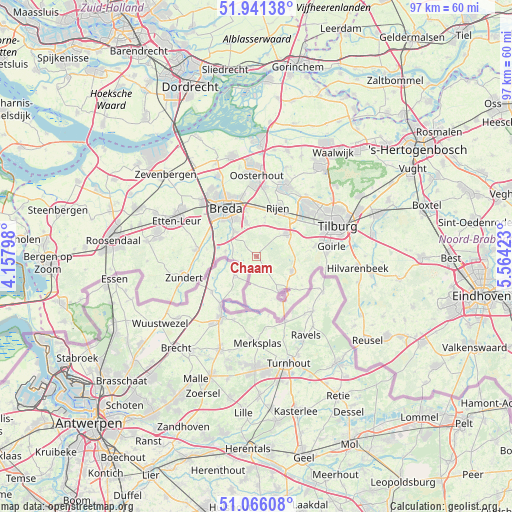
Chaam GPS coordinates[2]
51° 30' 20.988" North, 4° 51' 39.996" East
| Map corner | latitude | longitude |
|---|---|---|
| Upper-left | 51.94138°, | 4.15798° |
| Center: | 51.50583°, | 4.86111° |
| Lower-right: | 51.06608°, | 5.56423° |
| Map W x H: | 97.3×97.3 km | = 60.5×60.5mi |
| max Lat: | 53.48025° ⇑80.3% North |
| Chaam: | 51.50583° |
| min Lat: | ⇓19.7% South 50.76917° |
| min Long | Chaam | max Long |
| 3.38611° | 4.86111° | 7.16528° |
| W 22.4%⇐ | ⇒77.6% E |
Elevation
Elevation of Chaam is 13 m = 43 ft, and this is 2 m = 7 ft below average elevation for this country.
| Max E: |
203 m = 666 ft | 33% |
| Avg. | 15 m = 49 ft | |
| Chaam | 13 m = 43 ft | |
Min E: |
-6 m = -20 ft | 67% |
See also: Netherlands elevation on elevation.city.
Geographical zone
Chaam is located in North temperate zone (between Tropic of Cancer and the Arctic Circle). Distance of this North polar circle is 1674.3 km =1040.4 mi to North.| Distance of | km | miles | from Chaam |
|---|---|---|---|
| North Pole | 4280.2 | 2659.6 | to North |
| Arctic Circle | 1674.3 | 1040.4 | to North |
| Tropic Cancer | 3121 | 1939.3 | to South |
| Equator | 5726.9 | 3558.5 | to South |


Nearby cities:
15 places around Chaam: (largest is in red/bold)
• Alphen
7.2 km =4.5 mi,  111°
111°
• Baarle-Nassau
8 km =5 mi,  143°
143°
• Bavel
7 km =4.3 mi,  342°
342°
• Breda
10.7 km =6.6 mi,  326°
326°
• Dorst
9.4 km =5.8 mi,  358°
358°
• Galder
6 km =3.7 mi,  279°
279°
• Gilze
6.9 km =4.3 mi,  52°
52°
• Ginneken
8.2 km =5.1 mi,  324°
324°
• Heusdenhout
9.6 km =6 mi, 342°
• Hoogbraak
7.5 km =4.7 mi,  148°
148°
• Molenschot
7.6 km =4.7 mi,  10°
10°
• Rijen
10.3 km =6.4 mi,  23°
23°
• Rijsbergen
11.4 km =7.1 mi, 276°
• Ulvenhout
6.4 km =4 mi, 318°
• Zandberg
9.2 km =5.7 mi, 324°
Sources, notices
• [Note1] Compared only with cities in Netherlands existing in our database
• [Src1] Map data: © OpenStreetMap contributors (CC-BY-SA)
• [Src2] Other city data from geonames.org with taken over terms of usage.
• [Src3] Geographical zone / Annual Mean Temperature by Robert A. Rohde @ Wikipedia
