Britsum geodata
Britsum (Friesland) is a populated place; located in Netherlands in Europe/Amsterdam (GMT+2) time zone. With population of 910 people, there are 1455 cities with bigger population in this country. Compared to other cities in Netherlands, 96% of cities are located further ↓South; 56.8% of cities are located further ←West and 74.9% of cities have higher elevation than Britsum. Note1


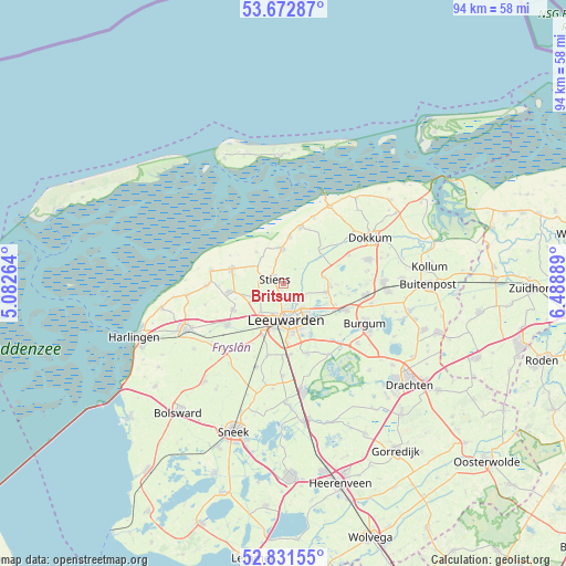
Britsum GPS coordinates[2]
53° 15' 15.408" North, 5° 47' 8.736" East
| Map corner | latitude | longitude |
|---|---|---|
| Upper-left | 53.67287°, | 5.08264° |
| Center: | 53.25428°, | 5.78576° |
| Lower-right: | 52.83155°, | 6.48889° |
| Map W x H: | 93.5×93.5 km | = 58.1×58.1mi |
| max Lat: | 53.48025° ⇑4% North |
| Britsum: | 53.25428° |
| min Lat: | ⇓96% South 50.76917° |
| min Long | Britsum | max Long |
| 3.38611° | 5.78576° | 7.16528° |
| W 56.8%⇐ | ⇒43.2% E |
Elevation
Elevation of Britsum is 2 m = 7 ft, and this is 13 m = 43 ft below average elevation for this country.
| Max E: |
203 m = 666 ft | 74.9% |
| Avg. | 15 m = 49 ft | |
| Britsum | 2 m = 7 ft | |
Min E: |
-6 m = -20 ft | 25.1% |
See also: Netherlands elevation on elevation.city.
Geographical zone
Britsum is located in North temperate zone (between Tropic of Cancer and the Arctic Circle). Distance of this North polar circle is 1479.9 km =919.6 mi to North.| Distance of | km | miles | from Britsum |
|---|---|---|---|
| North Pole | 4085.7 | 2538.7 | to North |
| Arctic Circle | 1479.9 | 919.6 | to North |
| Tropic Cancer | 3315.4 | 2060.1 | to South |
| Equator | 5921.3 | 3679.3 | to South |


Nearby cities:
15 places around Britsum: (largest is in red/bold)
• Aldtsjerk
6.9 km =4.3 mi,  78°
78°
• Bilgaard
4.4 km =2.7 mi,  171°
171°
• Burdaard
7.6 km =4.7 mi,  54°
54°
• Camminghaburen
6.3 km =3.9 mi,  142°
142°
• Gytsjerk
7.4 km =4.6 mi,  99°
99°
• Hallum
5.8 km =3.6 mi,  358°
358°
• Heechterp
5.5 km =3.4 mi,  153°
153°
• Hoek
5.6 km =3.5 mi, 168°
• Huizum
7.2 km =4.5 mi, 166°
• Leeuwarden
6.1 km =3.8 mi, 165°
• Marsum
6.3 km =3.9 mi,  219°
219°
• Oude Bildtzijl
6.8 km =4.2 mi,  318°
318°
• Stiens
2.1 km =1.3 mi,  295°
295°
• Vrouwenparochie
6.3 km =3.9 mi, 296°
• Westeinde
5.2 km =3.2 mi,  192°
192°
Sources, notices
• [Note1] Compared only with cities in Netherlands existing in our database
• [Src1] Map data: © OpenStreetMap contributors (CC-BY-SA)
• [Src2] Other city data from geonames.org with taken over terms of usage.
• [Src3] Geographical zone / Annual Mean Temperature by Robert A. Rohde @ Wikipedia
