Burdaard geodata
Burdaard (Friesland) is a populated place; located in Netherlands in Europe/Amsterdam (GMT+2) time zone. With population of 1,166 people, there are 1300 cities with bigger population in this country. Compared to other cities in Netherlands, 97.2% of cities are located further ↓South; 62.4% of cities are located further ←West and 83.9% of cities have higher elevation than Burdaard. Note1


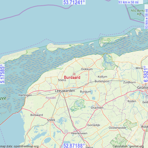
Burdaard GPS coordinates[2]
53° 17' 39.156" North, 5° 52' 44.292" East
| Map corner | latitude | longitude |
|---|---|---|
| Upper-left | 53.71241°, | 5.17585° |
| Center: | 53.29421°, | 5.87897° |
| Lower-right: | 52.87188°, | 6.5821° |
| Map W x H: | 93.5×93.5 km | = 58.1×58.1mi |
| max Lat: | 53.48025° ⇑2.8% North |
| Burdaard: | 53.29421° |
| min Lat: | ⇓97.2% South 50.76917° |
| min Long | Burdaard | max Long |
| 3.38611° | 5.87897° | 7.16528° |
| W 62.4%⇐ | ⇒37.6% E |
Elevation
Elevation of Burdaard is 1 m = 3 ft, and this is 14 m = 46 ft below average elevation for this country.
| Max E: |
203 m = 666 ft | 83.9% |
| Avg. | 15 m = 49 ft | |
| Burdaard | 1 m = 3 ft | |
Min E: |
-6 m = -20 ft | 16.1% |
See also: Netherlands elevation on elevation.city.
Geographical zone
Burdaard is located in North temperate zone (between Tropic of Cancer and the Arctic Circle). Distance of this North polar circle is 1475.4 km =916.8 mi to North.| Distance of | km | miles | from Burdaard |
|---|---|---|---|
| North Pole | 4081.3 | 2536 | to North |
| Arctic Circle | 1475.4 | 916.8 | to North |
| Tropic Cancer | 3319.8 | 2062.8 | to South |
| Equator | 5925.8 | 3682.1 | to South |


Nearby cities:
15 places around Burdaard: (largest is in red/bold)
• Aldtsjerk
3.1 km =1.9 mi,  170°
170°
• Blije
6.5 km =4 mi,  349°
349°
• Britsum
7.6 km =4.7 mi,  234°
234°
• Broeksterwâld
8.1 km =5 mi,  105°
105°
• Damwâld
7.9 km =4.9 mi,  93°
93°
• Dokkum
8.4 km =5.2 mi,  68°
68°
• Ferwert
6 km =3.7 mi,  323°
323°
• Gytsjerk
5.8 km =3.6 mi, 169°
• Hallum
6.5 km =4 mi,  282°
282°
• Holwerd
8.3 km =5.2 mi,  9°
9°
• Marrum
6 km =3.7 mi,  301°
301°
• Mûnein
5.4 km =3.4 mi,  149°
149°
• Oentsjerk
5.1 km =3.2 mi,  164°
164°
• Rinsumageast
4.7 km =2.9 mi, 86°
• Ryptsjerk
8.4 km =5.2 mi, 162°
Sources, notices
• [Note1] Compared only with cities in Netherlands existing in our database
• [Src1] Map data: © OpenStreetMap contributors (CC-BY-SA)
• [Src2] Other city data from geonames.org with taken over terms of usage.
• [Src3] Geographical zone / Annual Mean Temperature by Robert A. Rohde @ Wikipedia
