Boukoul geodata
Boukoul (Limburg) is a populated place; located in Netherlands in Europe/Amsterdam (GMT+2) time zone. With population of 935 people, there are 1439 cities with bigger population in this country. Compared to other cities in Netherlands, 91.2% of cities are located further ↑North; 75.8% of cities are located further ←West and 86.2% of cities have lower elevation than Boukoul. Note1


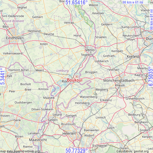
Boukoul GPS coordinates[2]
51° 12' 56.988" North, 6° 2' 49.992" East
| Map corner | latitude | longitude |
|---|---|---|
| Upper-left | 51.65416°, | 5.3441° |
| Center: | 51.21583°, | 6.04722° |
| Lower-right: | 50.77329°, | 6.75035° |
| Map W x H: | 97.9×97.9 km | = 60.8×60.8mi |
| max Lat: | 53.48025° ⇑91.2% North |
| Boukoul: | 51.21583° |
| min Lat: | ⇓8.8% South 50.76917° |
| min Long | Boukoul | max Long |
| 3.38611° | 6.04722° | 7.16528° |
| W 75.8%⇐ | ⇒24.2% E |
Elevation
Elevation of Boukoul is 28 m = 92 ft, and this is 13 m = 43 ft above average elevation for this country.
| Max E: |
203 m = 666 ft | 13.8% |
| Boukoul | 28 m 92 ft | |
| Avg. | 15 m = 49 ft | |
Min E: |
-6 m = -20 ft | 86.2% |
See also: Netherlands elevation on elevation.city.
Geographical zone
Boukoul is located in North temperate zone (between Tropic of Cancer and the Arctic Circle). Distance of this North polar circle is 1706.5 km =1060.4 mi to North.| Distance of | km | miles | from Boukoul |
|---|---|---|---|
| North Pole | 4312.4 | 2679.6 | to North |
| Arctic Circle | 1706.5 | 1060.4 | to North |
| Tropic Cancer | 3088.7 | 1919.2 | to South |
| Equator | 5694.7 | 3538.5 | to South |


Nearby cities:
15 places around Boukoul: (largest is in red/bold)
• Asenray
2.5 km =1.6 mi,  177°
177°
• Beesel
5.9 km =3.7 mi,  354°
354°
• Haelen
6.7 km =4.2 mi,  289°
289°
• Heide
2.8 km =1.7 mi, 354°
• Herkenbosch
7 km =4.3 mi,  170°
170°
• Herten
7.1 km =4.4 mi,  236°
236°
• Kessel
8.4 km =5.2 mi,  3°
3°
• Kesseleik
7.1 km =4.4 mi, 346°
• Kitskensberg
5.7 km =3.5 mi,  211°
211°
• Leeuwen
3.4 km =2.1 mi,  259°
259°
• Melick
6.7 km =4.2 mi,  198°
198°
• Merum
7.7 km =4.8 mi,  232°
232°
• Offenbeek
8.1 km =5 mi,  24°
24°
• Reuver
7.9 km =4.9 mi, 15°
• Roermond
4.8 km =3 mi, 239°
Sources, notices
• [Note1] Compared only with cities in Netherlands existing in our database
• [Src1] Map data: © OpenStreetMap contributors (CC-BY-SA)
• [Src2] Other city data from geonames.org with taken over terms of usage.
• [Src3] Geographical zone / Annual Mean Temperature by Robert A. Rohde @ Wikipedia
