Arkel geodata
Arkel (South Holland) is a populated place; located in Netherlands in Europe/Amsterdam (GMT+2) time zone. With population of 2,980 people, there are 760 cities with bigger population in this country. Compared to other cities in Netherlands, 60.5% of cities are located further ↑North; 73.8% of cities are located further →East and 83.9% of cities have higher elevation than Arkel. Note1


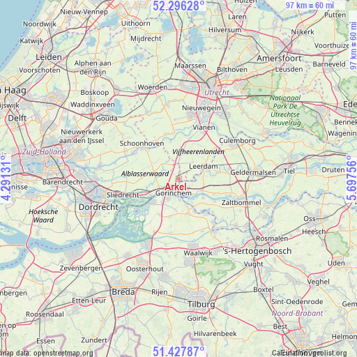
Arkel GPS coordinates[2]
51° 51' 51.012" North, 4° 59' 39.984" East
| Map corner | latitude | longitude |
|---|---|---|
| Upper-left | 52.29628°, | 4.29131° |
| Center: | 51.86417°, | 4.99444° |
| Lower-right: | 51.42787°, | 5.69756° |
| Map W x H: | 96.6×96.6 km | = 60×60mi |
| max Lat: | 53.48025° ⇑60.5% North |
| Arkel: | 51.86417° |
| min Lat: | ⇓39.5% South 50.76917° |
| min Long | Arkel | max Long |
| 3.38611° | 4.99444° | 7.16528° |
| W 26.2%⇐ | ⇒73.8% E |
Elevation
Elevation of Arkel is 1 m = 3 ft, and this is 14 m = 46 ft below average elevation for this country.
| Max E: |
203 m = 666 ft | 83.9% |
| Avg. | 15 m = 49 ft | |
| Arkel | 1 m = 3 ft | |
Min E: |
-6 m = -20 ft | 16.1% |
See also: Netherlands elevation on elevation.city.
Geographical zone
Arkel is located in North temperate zone (between Tropic of Cancer and the Arctic Circle). Distance of this North polar circle is 1634.4 km =1015.6 mi to North.| Distance of | km | miles | from Arkel |
|---|---|---|---|
| North Pole | 4240.3 | 2634.8 | to North |
| Arctic Circle | 1634.4 | 1015.6 | to North |
| Tropic Cancer | 3160.8 | 1964 | to South |
| Equator | 5766.8 | 3583.3 | to South |


Nearby cities:
15 places around Arkel: (largest is in red/bold)
• Boven-Hardinxveld
9 km =5.6 mi,  239°
239°
• Brakel
8.4 km =5.2 mi,  128°
128°
• Dalem
4.2 km =2.6 mi,  165°
165°
• Giessen
8.6 km =5.3 mi,  163°
163°
• Giessenburg
7.3 km =4.5 mi,  258°
258°
• Gorinchem
3.4 km =2.1 mi,  206°
206°
• Hoogblokland
1.7 km =1.1 mi,  314°
314°
• Kedichem
3.8 km =2.4 mi,  96°
96°
• Leerdam
7.4 km =4.6 mi,  64°
64°
• Noordeloos
5.7 km =3.5 mi,  320°
320°
• Rijswijk
7.7 km =4.8 mi, 164°
• Schelluinen
5.2 km =3.2 mi, 243°
• Vuren
5.6 km =3.5 mi,  140°
140°
• Werkendam
9.1 km =5.7 mi,  228°
228°
• Woudrichem
5.5 km =3.4 mi,  175°
175°
Sources, notices
• [Note1] Compared only with cities in Netherlands existing in our database
• [Src1] Map data: © OpenStreetMap contributors (CC-BY-SA)
• [Src2] Other city data from geonames.org with taken over terms of usage.
• [Src3] Geographical zone / Annual Mean Temperature by Robert A. Rohde @ Wikipedia
