Apeldoorn geodata
Apeldoorn (Gelderland) is a populated place; located in Netherlands in Europe/Amsterdam (GMT+2) time zone. With population of 136,670 people, there are 15 cities with bigger population in this country. Compared to other cities in Netherlands, 61.2% of cities are located further ↓South; 70% of cities are located further ←West and 74.9% of cities have lower elevation than Apeldoorn. Note1


Apeldoorn GPS coordinates[2]
52° 12' 36" North, 5° 58' 9.984" East
| Map corner | latitude | longitude |
|---|---|---|
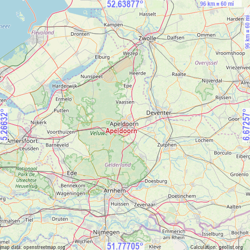
| Upper-left | 52.63877°, | 5.26632° |
| Center: | 52.21°, | 5.96944° |
| Lower-right: | 51.77705°, | 6.67257° |
| Map W x H: | 95.8×95.8 km | = 59.5×59.5mi |
| max Lat: | 53.48025° ⇑38.8% North |
| Apeldoorn: | 52.21° |
| min Lat: | ⇓61.2% South 50.76917° |
| min Long | Apeldoorn | max Long |
| 3.38611° | 5.96944° | 7.16528° |
| W 70%⇐ | ⇒30% E |
Elevation
Elevation of Apeldoorn is 18 m = 59 ft, and this is 3 m = 10 ft above average elevation for this country.
| Max E: |
203 m = 666 ft | 25.1% |
| Apeldoorn | 18 m 59 ft | |
| Avg. | 15 m = 49 ft | |
Min E: |
-6 m = -20 ft | 74.9% |
See also: Apeldoorn elevation on elevation.city.
Geographical zone
Apeldoorn is located in North temperate zone (between Tropic of Cancer and the Arctic Circle). Distance of this North polar circle is 1596 km =991.7 mi to North.| Distance of | km | miles | from Apeldoorn |
|---|---|---|---|
| North Pole | 4201.9 | 2610.9 | to North |
| Arctic Circle | 1596 | 991.7 | to North |
| Tropic Cancer | 3199.3 | 1988 | to South |
| Equator | 5805.2 | 3607.2 | to South |


Nearby cities:
15 places around Apeldoorn: (largest is in red/bold)
• Binnenstad
0.8 km =0.5 mi,  296°
296°
• Brinkhorst
1.3 km =0.8 mi,  285°
285°
• Brummelhof
0.6 km =0.4 mi,  190°
190°
• De Haven
0.3 km =0.2 mi,  80°
80°
• De Heeze
1.5 km =0.9 mi,  225°
225°
• De Mheen
1.8 km =1.1 mi,  54°
54°
• Driehuizen
1.7 km =1.1 mi,  265°
265°
• Matendreef
1.6 km =1 mi,  134°
134°
• Matenhorst
1.7 km =1.1 mi,  109°
109°
• Sluisoord
1.7 km =1.1 mi,  29°
29°
• Sprengenweg-Noord
1.6 km =1 mi,  306°
306°
• Staatsliedenkwartier
1.3 km =0.8 mi,  156°
156°
• Vogelkwartier
1.4 km =0.9 mi, 186°
• Welgelegen
0.6 km =0.4 mi, 47°
• Zevenhuizen
1.1 km =0.7 mi, 33°
Sources, notices
• [Note1] Compared only with cities in Netherlands existing in our database
• [Src1] Map data: © OpenStreetMap contributors (CC-BY-SA)
• [Src2] Other city data from geonames.org with taken over terms of usage.
• [Src3] Geographical zone / Annual Mean Temperature by Robert A. Rohde @ Wikipedia
