Matenhorst geodata
Matenhorst (Gelderland) is a section of populated place; located in Netherlands in Europe/Amsterdam (GMT+2) time zone. With population of 3,055 people, there are 746 cities with bigger population in this country. Compared to other cities in Netherlands, 60.8% of cities are located further ↓South; 72.3% of cities are located further ←West and 67% of cities have lower elevation than Matenhorst. Note1


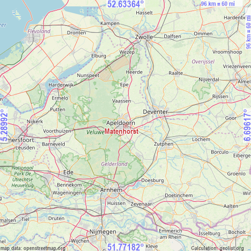
Matenhorst GPS coordinates[2]
52° 12' 17.352" North, 5° 59' 34.944" East
| Map corner | latitude | longitude |
|---|---|---|
| Upper-left | 52.63364°, | 5.28992° |
| Center: | 52.20482°, | 5.99304° |
| Lower-right: | 51.77182°, | 6.69617° |
| Map W x H: | 95.8×95.8 km | = 59.5×59.5mi |
| max Lat: | 53.48025° ⇑39.2% North |
| Matenhorst: | 52.20482° |
| min Lat: | ⇓60.8% South 50.76917° |
| min Long | Matenhorst | max Long |
| 3.38611° | 5.99304° | 7.16528° |
| W 72.3%⇐ | ⇒27.7% E |
Elevation
Elevation of Matenhorst is 13 m = 43 ft, and this is 2 m = 7 ft below average elevation for this country.
| Max E: |
203 m = 666 ft | 33% |
| Avg. | 15 m = 49 ft | |
| Matenhorst | 13 m = 43 ft | |
Min E: |
-6 m = -20 ft | 67% |
See also: Netherlands elevation on elevation.city.
Geographical zone
Matenhorst is located in North temperate zone (between Tropic of Cancer and the Arctic Circle). Distance of this North polar circle is 1596.5 km =992 mi to North.| Distance of | km | miles | from Matenhorst |
|---|---|---|---|
| North Pole | 4202.4 | 2611.2 | to North |
| Arctic Circle | 1596.5 | 992 | to North |
| Tropic Cancer | 3198.7 | 1987.6 | to South |
| Equator | 5804.6 | 3606.8 | to South |


Nearby cities:
15 places around Matenhorst: (largest is in red/bold)
• Apeldoorn
1.7 km =1.1 mi,  289°
289°
• Brummelhof
1.7 km =1.1 mi,  270°
270°
• De Haven
1.4 km =0.9 mi,  295°
295°
• De Mheen
1.6 km =1 mi,  356°
356°
• Matendonk
1.5 km =0.9 mi,  122°
122°
• Matendreef
0.7 km =0.4 mi,  221°
221°
• Matengaarde
0.8 km =0.5 mi,  166°
166°
• Matenhoeve
2.1 km =1.3 mi,  138°
138°
• Matenveld
1.9 km =1.2 mi, 168°
• Rivierenkwartier
2.1 km =1.3 mi,  212°
212°
• Staatsliedenkwartier
1.2 km =0.7 mi,  241°
241°
• Vogelkwartier
1.9 km =1.2 mi,  245°
245°
• Welgelegen
1.5 km =0.9 mi,  311°
311°
• Woudhuis
1.6 km =1 mi,  52°
52°
• Zevenhuizen
1.8 km =1.1 mi,  326°
326°
Sources, notices
• [Note1] Compared only with cities in Netherlands existing in our database
• [Src1] Map data: © OpenStreetMap contributors (CC-BY-SA)
• [Src2] Other city data from geonames.org with taken over terms of usage.
• [Src3] Geographical zone / Annual Mean Temperature by Robert A. Rohde @ Wikipedia
