Vogelkwartier geodata
Vogelkwartier (Gelderland) is a section of populated place; located in Netherlands in Europe/Amsterdam (GMT+2) time zone. With population of 4,975 people, there are 486 cities with bigger population in this country. Compared to other cities in Netherlands, 60.2% of cities are located further ↓South; 69.8% of cities are located further ←West and 74.9% of cities have lower elevation than Vogelkwartier. Note1


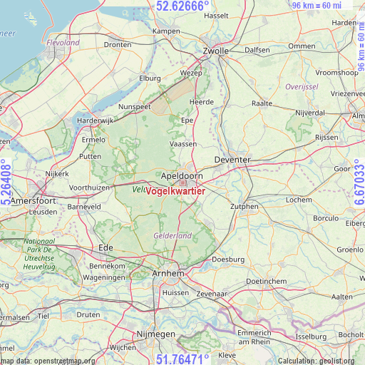
Vogelkwartier GPS coordinates[2]
52° 11' 51.972" North, 5° 58' 1.956" East
| Map corner | latitude | longitude |
|---|---|---|
| Upper-left | 52.62666°, | 5.26408° |
| Center: | 52.19777°, | 5.96721° |
| Lower-right: | 51.76471°, | 6.67033° |
| Map W x H: | 95.8×95.8 km | = 59.5×59.5mi |
| max Lat: | 53.48025° ⇑39.8% North |
| Vogelkwartier: | 52.19777° |
| min Lat: | ⇓60.2% South 50.76917° |
| min Long | Vogelkwartier | max Long |
| 3.38611° | 5.96721° | 7.16528° |
| W 69.8%⇐ | ⇒30.2% E |
Elevation
Elevation of Vogelkwartier is 18 m = 59 ft, and this is 3 m = 10 ft above average elevation for this country.
| Max E: |
203 m = 666 ft | 25.1% |
| Vogelkwartier | 18 m 59 ft | |
| Avg. | 15 m = 49 ft | |
Min E: |
-6 m = -20 ft | 74.9% |
See also: Netherlands elevation on elevation.city.
Geographical zone
Vogelkwartier is located in North temperate zone (between Tropic of Cancer and the Arctic Circle). Distance of this North polar circle is 1597.3 km =992.5 mi to North.| Distance of | km | miles | from Vogelkwartier |
|---|---|---|---|
| North Pole | 4203.2 | 2611.7 | to North |
| Arctic Circle | 1597.3 | 992.5 | to North |
| Tropic Cancer | 3197.9 | 1987.1 | to South |
| Equator | 5803.8 | 3606.3 | to South |


Nearby cities:
15 places around Vogelkwartier: (largest is in red/bold)
• Apeldoorn
1.4 km =0.9 mi,  6°
6°
• Binnenstad
1.8 km =1.1 mi,  342°
342°
• Brummelhof
0.8 km =0.5 mi,  3°
3°
• Componistenkwartier
0.9 km =0.6 mi,  184°
184°
• De Bouwhof
1.9 km =1.2 mi,  225°
225°
• De Haven
1.5 km =0.9 mi,  18°
18°
• De Heeze
1 km =0.6 mi,  288°
288°
• Matendreef
1.3 km =0.8 mi,  79°
79°
• Matengaarde
1.9 km =1.2 mi,  89°
89°
• Matenhorst
1.9 km =1.2 mi,  65°
65°
• Rivierenkwartier
1.2 km =0.7 mi,  146°
146°
• Staatsliedenkwartier
0.7 km =0.4 mi, 73°
• Welgelegen
1.9 km =1.2 mi, 19°
• Westenenk
0.7 km =0.4 mi,  256°
256°
• Winkewijert
1 km =0.6 mi,  219°
219°
Sources, notices
• [Note1] Compared only with cities in Netherlands existing in our database
• [Src1] Map data: © OpenStreetMap contributors (CC-BY-SA)
• [Src2] Other city data from geonames.org with taken over terms of usage.
• [Src3] Geographical zone / Annual Mean Temperature by Robert A. Rohde @ Wikipedia
