Utsira geodata
Utsira (Rogaland) is a seat of a second-order administrative division; located in Norway in Europe/Oslo (GMT+2) time zone. In our database, there are 488 cities with bigger population. Compared to other cities in Norway, 83.2% of cities are located further ↑North; 99.5% of cities are located further →East and 75.8% of cities have higher elevation than Utsira. Note1


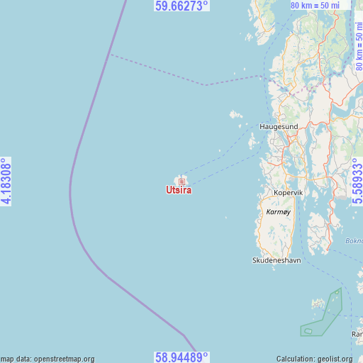
Utsira GPS coordinates[2]
59° 18' 20.52" North, 4° 53' 10.32" East
| Map corner | latitude | longitude |
|---|---|---|
| Upper-left | 59.66273°, | 4.18308° |
| Center: | 59.3057°, | 4.8862° |
| Lower-right: | 58.94489°, | 5.58933° |
| Map W x H: | 79.8×79.8 km | = 49.6×49.6mi |
| max Lat: | 71.04137° ⇑83.2% North |
| Utsira: | 59.3057° |
| min Lat: | ⇓16.8% South 58.0274° |
| min Long | Utsira | max Long |
| 4.71485° | 4.8862° | 31.11066° |
| W 0.5%⇐ | ⇒99.5% E |
Elevation
Elevation of Utsira is 13 m = 43 ft, and this is 91.2 m = 299 ft below average elevation for this country.
| Max E: |
897 m = 2943 ft | 75.8% |
| Avg. | 104.2 m = 342 ft | |
| Utsira | 13 m = 43 ft | |
Min E: |
1 m = 3 ft | 24.2% |
See also: Norway elevation on elevation.city.
Geographical zone
Utsira is located in North temperate zone (between Tropic of Cancer and the Arctic Circle). Distance of this North polar circle is 807 km =501.4 mi to North.| Distance of | km | miles | from Utsira |
|---|---|---|---|
| North Pole | 3412.9 | 2120.7 | to North |
| Arctic Circle | 807 | 501.4 | to North |
| Tropic Cancer | 3988.3 | 2478.2 | to South |
| Equator | 6594.2 | 4097.4 | to South |


Nearby cities:
15 places around Utsira: (largest is in red/bold)
• Aksdal
34.3 km =21.3 mi,  67°
67°
• Bokn
32.3 km =20.1 mi,  104°
104°
• Eike
29 km =18 mi, 69°
• Haugesund
24.7 km =15.3 mi,  60°
60°
• Kopervik
24 km =14.9 mi, 95°
• Langevåg
38.9 km =24.2 mi,  30°
30°
• Skudeneshavn
27.4 km =17 mi,  129°
129°
• Sveio
37.2 km =23.1 mi,  45°
45°
• Sæveland
18.3 km =11.4 mi, 103°
• Tysvær
34.4 km =21.4 mi,  85°
85°
• Vedavågen
18.9 km =11.7 mi, 93°
• Visnes
20.7 km =12.9 mi, 74°
• Vormedal
25.2 km =15.7 mi,  77°
77°
• Ydstebøhamn
40 km =24.9 mi, 132°
• Åkrehamn
17.8 km =11.1 mi,  106°
106°
Sources, notices
• [Note1] Compared only with cities in Norway existing in our database
• [Src1] Map data: © OpenStreetMap contributors (CC-BY-SA)
• [Src2] Other city data from geonames.org with taken over terms of usage.
• [Src3] Geographical zone / Annual Mean Temperature by Robert A. Rohde @ Wikipedia
