Ydstebøhamn geodata
Ydstebøhamn (Rogaland) is a seat of a second-order administrative division; located in Norway in Europe/Oslo (GMT+2) time zone. In our database, there are 488 cities with bigger population. Compared to other cities in Norway, 89.2% of cities are located further ↑North; 91.6% of cities are located further →East and 81.6% of cities have higher elevation than Ydstebøhamn. Note1


Ydstebøhamn GPS coordinates[2]
59° 3' 44.172" North, 5° 24' 8.964" East
| Map corner | latitude | longitude |
|---|---|---|
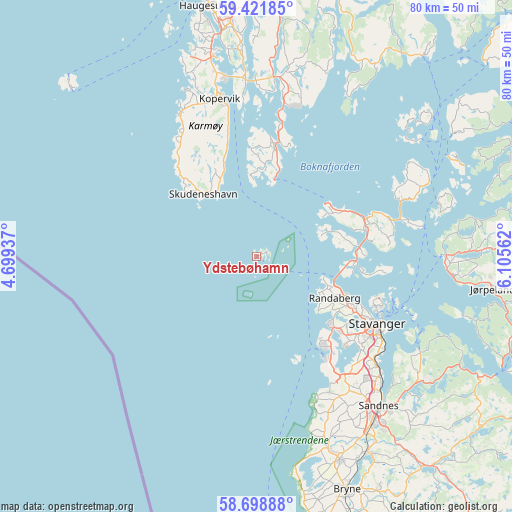
| Upper-left | 59.42185°, | 4.69937° |
| Center: | 59.06227°, | 5.40249° |
| Lower-right: | 58.69888°, | 6.10562° |
| Map W x H: | 80.4×80.4 km | = 50×50mi |
| max Lat: | 71.04137° ⇑89.2% North |
| Ydstebøhamn: | 59.06227° |
| min Lat: | ⇓10.8% South 58.0274° |
| min Long | Ydstebøhamn | max Long |
| 4.71485° | 5.40249° | 31.11066° |
| W 8.4%⇐ | ⇒91.6% E |
Elevation
Elevation of Ydstebøhamn is 10 m = 33 ft, and this is 94.2 m = 309 ft below average elevation for this country.
| Max E: |
897 m = 2943 ft | 81.6% |
| Avg. | 104.2 m = 342 ft | |
| Ydstebøhamn | 10 m = 33 ft | |
Min E: |
1 m = 3 ft | 18.4% |
See also: Norway elevation on elevation.city.
Geographical zone
Ydstebøhamn is located in North temperate zone (between Tropic of Cancer and the Arctic Circle). Distance of this North polar circle is 834.1 km =518.3 mi to North.| Distance of | km | miles | from Ydstebøhamn |
|---|---|---|---|
| North Pole | 3440 | 2137.5 | to North |
| Arctic Circle | 834.1 | 518.3 | to North |
| Tropic Cancer | 3961.2 | 2461.4 | to South |
| Equator | 6567.1 | 4080.6 | to South |


Nearby cities:
15 places around Ydstebøhamn: (largest is in red/bold)
• Bokn
18.8 km =11.7 mi,  5°
5°
• Hommersåk
29.9 km =18.6 mi,  120°
120°
• Judaberg
29.7 km =18.5 mi,  65°
65°
• Kopervik
25.2 km =15.7 mi,  347°
347°
• Randaberg
14.2 km =8.8 mi, 119°
• Sandnes
30.1 km =18.7 mi,  140°
140°
• Skudeneshavn
12.7 km =7.9 mi,  319°
319°
• Sola
24.1 km =15 mi, 143°
• Stavanger
21.5 km =13.4 mi, 118°
• Sæveland
25.5 km =15.8 mi,  333°
333°
• Tananger
17.1 km =10.6 mi, 144°
• Tau
29.7 km =18.5 mi,  89°
89°
• Vedavågen
27.9 km =17.3 mi,  337°
337°
• Vikevåg
17.3 km =10.7 mi,  76°
76°
• Åkrehamn
25.2 km =15.7 mi, 330°
Sources, notices
• [Note1] Compared only with cities in Norway existing in our database
• [Src1] Map data: © OpenStreetMap contributors (CC-BY-SA)
• [Src2] Other city data from geonames.org with taken over terms of usage.
• [Src3] Geographical zone / Annual Mean Temperature by Robert A. Rohde @ Wikipedia
