Skogn geodata
Skogn (Trøndelag) is a populated place; located in Norway in Europe/Oslo (GMT+2) time zone. With population of 1,884 people, there are 211 cities with bigger population in this country. Compared to other cities in Norway, 78.5% of cities are located further ↓South; 71.7% of cities are located further ←West and 61.6% of cities have lower elevation than Skogn. Note1


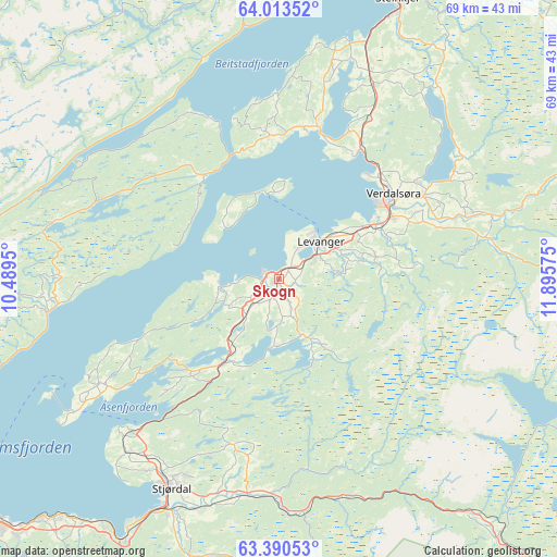
Skogn GPS coordinates[2]
63° 42' 13.464" North, 11° 11' 33.432" East
| Map corner | latitude | longitude |
|---|---|---|
| Upper-left | 64.01352°, | 10.4895° |
| Center: | 63.70374°, | 11.19262° |
| Lower-right: | 63.39053°, | 11.89575° |
| Map W x H: | 69.3×69.3 km | = 43.1×43.1mi |
| max Lat: | 71.04137° ⇑21.5% North |
| Skogn: | 63.70374° |
| min Lat: | ⇓78.5% South 58.0274° |
| min Long | Skogn | max Long |
| 4.71485° | 11.19262° | 31.11066° |
| W 71.7%⇐ | ⇒28.3% E |
Elevation
Elevation of Skogn is 73 m = 240 ft, and this is 31.2 m = 102 ft below average elevation for this country.
| Max E: |
897 m = 2943 ft | 38.4% |
| Avg. | 104.2 m = 342 ft | |
| Skogn | 73 m = 240 ft | |
Min E: |
1 m = 3 ft | 61.6% |
See also: Norway elevation on elevation.city.
Geographical zone
Skogn is located in North temperate zone (between Tropic of Cancer and the Arctic Circle). Distance of this North polar circle is 318 km =197.6 mi to North.| Distance of | km | miles | from Skogn |
|---|---|---|---|
| North Pole | 2923.9 | 1816.8 | to North |
| Arctic Circle | 318 | 197.6 | to North |
| Tropic Cancer | 4477.3 | 2782.1 | to South |
| Equator | 7083.2 | 4401.3 | to South |


Nearby cities:
15 places around Skogn: (largest is in red/bold)
• Frosta
25.6 km =15.9 mi,  240°
240°
• Hegra
26.9 km =16.7 mi,  188°
188°
• Hell
32.1 km =19.9 mi,  206°
206°
• Hommelvik
38.1 km =23.7 mi, 211°
• Leksvik
28.3 km =17.6 mi,  262°
262°
• Levanger
7.1 km =4.4 mi,  47°
47°
• Malm
41.3 km =25.7 mi,  2°
2°
• Malvik
39.2 km =24.4 mi,  219°
219°
• Meråker
42.2 km =26.2 mi,  139°
139°
• Sparbu
26.7 km =16.6 mi,  26°
26°
• Steinkjer
37.6 km =23.4 mi,  23°
23°
• Stjørdal
29.5 km =18.3 mi, 207°
• Stjørdalshalsen
29.3 km =18.2 mi, 206°
• Straumen
19.3 km =12 mi, 15°
• Verdal
17.4 km =10.8 mi, 54°
Sources, notices
• [Note1] Compared only with cities in Norway existing in our database
• [Src1] Map data: © OpenStreetMap contributors (CC-BY-SA)
• [Src2] Other city data from geonames.org with taken over terms of usage.
• [Src3] Geographical zone / Annual Mean Temperature by Robert A. Rohde @ Wikipedia
