Meråker geodata
Meråker (Trøndelag) is a seat of a second-order administrative division; located in Norway in Europe/Oslo (GMT+2) time zone. With population of 961 people, there are 320 cities with bigger population in this country. Compared to other cities in Norway, 76.3% of cities are located further ↓South; 79.7% of cities are located further ←West and 85.4% of cities have lower elevation than Meråker. Note1


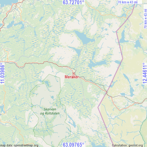
Meråker GPS coordinates[2]
63° 24' 50.616" North, 11° 44' 34.728" East
| Map corner | latitude | longitude |
|---|---|---|
| Upper-left | 63.72701°, | 11.03986° |
| Center: | 63.41406°, | 11.74298° |
| Lower-right: | 63.09765°, | 12.44611° |
| Map W x H: | 70×70 km | = 43.5×43.5mi |
| max Lat: | 71.04137° ⇑23.7% North |
| Meråker: | 63.41406° |
| min Lat: | ⇓76.3% South 58.0274° |
| min Long | Meråker | max Long |
| 4.71485° | 11.74298° | 31.11066° |
| W 79.7%⇐ | ⇒20.3% E |
Elevation
Elevation of Meråker is 206 m = 676 ft, and this is 101.8 m = 334 ft above average elevation for this country.
| Max E: |
897 m = 2943 ft | 14.6% |
| Meråker | 206 m 676 ft | |
| Avg. | 104.2 m = 342 ft | |
Min E: |
1 m = 3 ft | 85.4% |
See also: Norway elevation on elevation.city.
Geographical zone
Meråker is located in North temperate zone (between Tropic of Cancer and the Arctic Circle). Distance of this North polar circle is 350.2 km =217.6 mi to North.| Distance of | km | miles | from Meråker |
|---|---|---|---|
| North Pole | 2956.1 | 1836.8 | to North |
| Arctic Circle | 350.2 | 217.6 | to North |
| Tropic Cancer | 4445.1 | 2762.1 | to South |
| Equator | 7051 | 4381.3 | to South |


Nearby cities:
15 places around Meråker: (largest is in red/bold)
• Aas
40.7 km =25.3 mi,  186°
186°
• Frosta
53.3 km =33.1 mi,  291°
291°
• Hegra
31.7 km =19.7 mi,  280°
280°
• Hell
42 km =26.1 mi,  274°
274°
• Hommelvik
47.2 km =29.3 mi, 269°
• Leksvik
62.5 km =38.8 mi,  297°
297°
• Levanger
43 km =26.7 mi,  329°
329°
• Malvik
52.8 km =32.8 mi, 272°
• Mebonden
41 km =25.5 mi,  240°
240°
• Skogn
42.2 km =26.2 mi,  319°
319°
• Sparbu
58.2 km =36.2 mi,  344°
344°
• Stjørdal
41.5 km =25.8 mi, 278°
• Stjørdalshalsen
41 km =25.5 mi, 278°
• Straumen
55.5 km =34.5 mi, 336°
• Verdal
44.1 km =27.4 mi, 342°
Sources, notices
• [Note1] Compared only with cities in Norway existing in our database
• [Src1] Map data: © OpenStreetMap contributors (CC-BY-SA)
• [Src2] Other city data from geonames.org with taken over terms of usage.
• [Src3] Geographical zone / Annual Mean Temperature by Robert A. Rohde @ Wikipedia
