Rygge geodata
Rygge (Østfold) is a seat of a second-order administrative division; located in Norway in Europe/Oslo (GMT+2) time zone. With population of 2,567 people, there are 146 cities with bigger population in this country. Compared to other cities in Norway, 81.5% of cities are located further ↑North; 63.4% of cities are located further ←West and 58.7% of cities have higher elevation than Rygge. Note1


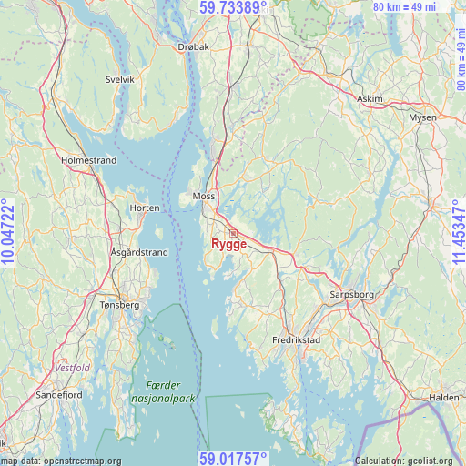
Rygge GPS coordinates[2]
59° 22' 39.432" North, 10° 45' 1.224" East
| Map corner | latitude | longitude |
|---|---|---|
| Upper-left | 59.73389°, | 10.04722° |
| Center: | 59.37762°, | 10.75034° |
| Lower-right: | 59.01757°, | 11.45347° |
| Map W x H: | 79.6×79.6 km | = 49.5×49.5mi |
| max Lat: | 71.04137° ⇑81.5% North |
| Rygge: | 59.37762° |
| min Lat: | ⇓18.5% South 58.0274° |
| min Long | Rygge | max Long |
| 4.71485° | 10.75034° | 31.11066° |
| W 63.4%⇐ | ⇒36.6% E |
Elevation
Elevation of Rygge is 29 m = 95 ft, and this is 75.2 m = 247 ft below average elevation for this country.
| Max E: |
897 m = 2943 ft | 58.7% |
| Avg. | 104.2 m = 342 ft | |
| Rygge | 29 m = 95 ft | |
Min E: |
1 m = 3 ft | 41.3% |
See also: Norway elevation on elevation.city.
Geographical zone
Rygge is located in North temperate zone (between Tropic of Cancer and the Arctic Circle). Distance of this North polar circle is 799 km =496.5 mi to North.| Distance of | km | miles | from Rygge |
|---|---|---|---|
| North Pole | 3404.9 | 2115.7 | to North |
| Arctic Circle | 799 | 496.5 | to North |
| Tropic Cancer | 3996.3 | 2483.2 | to South |
| Equator | 6602.2 | 4102.4 | to South |


Nearby cities:
15 places around Rygge: (largest is in red/bold)
• Barkåker
21.5 km =13.4 mi,  252°
252°
• Fredrikstad
20.5 km =12.7 mi,  150°
150°
• Horten
15.7 km =9.8 mi,  286°
286°
• Karlshus
7.5 km =4.7 mi,  112°
112°
• Kirkebygda
14.5 km =9 mi,  28°
28°
• Larkollen
6.9 km =4.3 mi,  222°
222°
• Lervik
11.8 km =7.3 mi,  181°
181°
• Moss
8.2 km =5.1 mi,  320°
320°
• Nykirke
21.3 km =13.2 mi,  283°
283°
• Ryggebyen
0.3 km =0.2 mi, 183°
• Sarpsborg
22.9 km =14.2 mi,  117°
117°
• Skoppum
19.3 km =12 mi,  272°
272°
• Slevik
20.6 km =12.8 mi,  168°
168°
• Tofte
21.2 km =13.2 mi,  329°
329°
• Åsgårdstrand
16.2 km =10.1 mi,  258°
258°
Sources, notices
• [Note1] Compared only with cities in Norway existing in our database
• [Src1] Map data: © OpenStreetMap contributors (CC-BY-SA)
• [Src2] Other city data from geonames.org with taken over terms of usage.
• [Src3] Geographical zone / Annual Mean Temperature by Robert A. Rohde @ Wikipedia
