Barkåker geodata
Barkåker (Vestfold) is a populated locality; located in Norway in Europe/Oslo (GMT+2) time zone. With population of 1,238 people, there are 264 cities with bigger population in this country. Compared to other cities in Norway, 82.9% of cities are located further ↑North; 55.9% of cities are located further ←West and 53.3% of cities have lower elevation than Barkåker. Note1


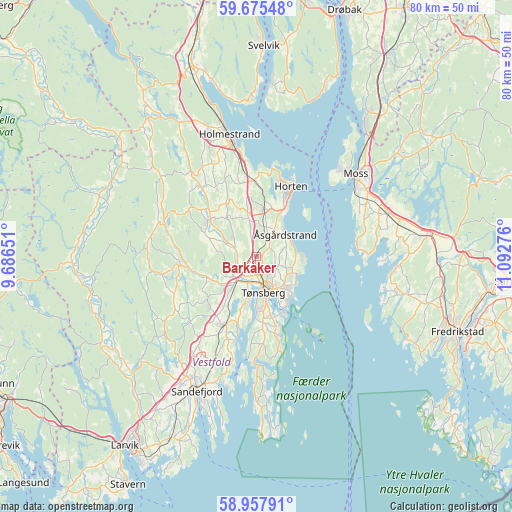
Barkåker GPS coordinates[2]
59° 19' 6.924" North, 10° 23' 22.668" East
| Map corner | latitude | longitude |
|---|---|---|
| Upper-left | 59.67548°, | 9.68651° |
| Center: | 59.31859°, | 10.38963° |
| Lower-right: | 58.95791°, | 11.09276° |
| Map W x H: | 79.8×79.8 km | = 49.6×49.6mi |
| max Lat: | 71.04137° ⇑82.9% North |
| Barkåker: | 59.31859° |
| min Lat: | ⇓17.1% South 58.0274° |
| min Long | Barkåker | max Long |
| 4.71485° | 10.38963° | 31.11066° |
| W 55.9%⇐ | ⇒44.1% E |
Elevation
Elevation of Barkåker is 53 m = 174 ft, and this is 51.2 m = 168 ft below average elevation for this country.
| Max E: |
897 m = 2943 ft | 46.7% |
| Avg. | 104.2 m = 342 ft | |
| Barkåker | 53 m = 174 ft | |
Min E: |
1 m = 3 ft | 53.3% |
See also: Norway elevation on elevation.city.
Geographical zone
Barkåker is located in North temperate zone (between Tropic of Cancer and the Arctic Circle). Distance of this North polar circle is 805.6 km =500.6 mi to North.| Distance of | km | miles | from Barkåker |
|---|---|---|---|
| North Pole | 3411.5 | 2119.8 | to North |
| Arctic Circle | 805.6 | 500.6 | to North |
| Tropic Cancer | 3989.7 | 2479.1 | to South |
| Equator | 6595.6 | 4098.3 | to South |


Nearby cities:
15 places around Barkåker: (largest is in red/bold)
• Andebu
12.2 km =7.6 mi,  263°
263°
• Borgheim
10.3 km =6.4 mi,  174°
174°
• Holmestrand
19.2 km =11.9 mi,  347°
347°
• Horten
12.2 km =7.6 mi,  25°
25°
• Larkollen
15.8 km =9.8 mi,  84°
84°
• Melsomvik
11 km =6.8 mi,  196°
196°
• Moss
19.9 km =12.4 mi,  49°
49°
• Nykirke
11.6 km =7.2 mi,  358°
358°
• Revetal
9.3 km =5.8 mi,  309°
309°
• Sem
5.3 km =3.3 mi,  219°
219°
• Skoppum
7.6 km =4.7 mi,  9°
9°
• Stokke
11.8 km =7.3 mi,  205°
205°
• Tønsberg
5.8 km =3.6 mi, 169°
• Årøysund
15.5 km =9.6 mi, 165°
• Åsgårdstrand
5.7 km =3.5 mi, 52°
Sources, notices
• [Note1] Compared only with cities in Norway existing in our database
• [Src1] Map data: © OpenStreetMap contributors (CC-BY-SA)
• [Src2] Other city data from geonames.org with taken over terms of usage.
• [Src3] Geographical zone / Annual Mean Temperature by Robert A. Rohde @ Wikipedia
