Karlshus geodata
Karlshus (Østfold) is a seat of a second-order administrative division; located in Norway in Europe/Oslo (GMT+2) time zone. With population of 1,801 people, there are 221 cities with bigger population in this country. Compared to other cities in Norway, 82.3% of cities are located further ↑North; 65.2% of cities are located further ←West and 52.2% of cities have lower elevation than Karlshus. Note1


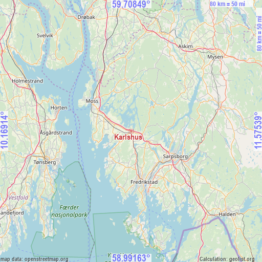
Karlshus GPS coordinates[2]
59° 21' 7.02" North, 10° 52' 20.136" East
| Map corner | latitude | longitude |
|---|---|---|
| Upper-left | 59.70849°, | 10.16914° |
| Center: | 59.35195°, | 10.87226° |
| Lower-right: | 58.99163°, | 11.57539° |
| Map W x H: | 79.7×79.7 km | = 49.5×49.5mi |
| max Lat: | 71.04137° ⇑82.3% North |
| Karlshus: | 59.35195° |
| min Lat: | ⇓17.7% South 58.0274° |
| min Long | Karlshus | max Long |
| 4.71485° | 10.87226° | 31.11066° |
| W 65.2%⇐ | ⇒34.8% E |
Elevation
Elevation of Karlshus is 49 m = 161 ft, and this is 55.2 m = 181 ft below average elevation for this country.
| Max E: |
897 m = 2943 ft | 47.8% |
| Avg. | 104.2 m = 342 ft | |
| Karlshus | 49 m = 161 ft | |
Min E: |
1 m = 3 ft | 52.2% |
See also: Norway elevation on elevation.city.
Geographical zone
Karlshus is located in North temperate zone (between Tropic of Cancer and the Arctic Circle). Distance of this North polar circle is 801.9 km =498.3 mi to North.| Distance of | km | miles | from Karlshus |
|---|---|---|---|
| North Pole | 3407.7 | 2117.4 | to North |
| Arctic Circle | 801.9 | 498.3 | to North |
| Tropic Cancer | 3993.4 | 2481.4 | to South |
| Equator | 6599.3 | 4100.6 | to South |


Nearby cities:
15 places around Karlshus: (largest is in red/bold)
• Fredrikstad
15.2 km =9.4 mi,  167°
167°
• Horten
23.2 km =14.4 mi,  288°
288°
• Ise
20.6 km =12.8 mi,  106°
106°
• Kirkebygda
15.6 km =9.7 mi,  0°
0°
• Larkollen
11.9 km =7.4 mi,  259°
259°
• Lervik
11.5 km =7.1 mi,  218°
218°
• Meieribyen
21.3 km =13.2 mi,  50°
50°
• Moss
15.2 km =9.4 mi,  306°
306°
• Rygge
7.5 km =4.7 mi, 292°
• Ryggebyen
7.4 km =4.6 mi, 290°
• Sarpsborg
15.4 km =9.6 mi,  119°
119°
• Skjeberg
23.9 km =14.9 mi,  130°
130°
• Skoppum
26.4 km =16.4 mi,  278°
278°
• Slevik
17.5 km =10.9 mi,  188°
188°
• Åsgårdstrand
22.8 km =14.2 mi,  269°
269°
Sources, notices
• [Note1] Compared only with cities in Norway existing in our database
• [Src1] Map data: © OpenStreetMap contributors (CC-BY-SA)
• [Src2] Other city data from geonames.org with taken over terms of usage.
• [Src3] Geographical zone / Annual Mean Temperature by Robert A. Rohde @ Wikipedia
