Skoppum geodata
Skoppum (Vestfold) is a populated place; located in Norway in Europe/Oslo (GMT+2) time zone. With population of 1,633 people, there are 232 cities with bigger population in this country. Compared to other cities in Norway, 81.3% of cities are located further ↑North; 56.8% of cities are located further ←West and 50.6% of cities have lower elevation than Skoppum. Note1


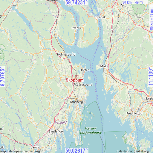
Skoppum GPS coordinates[2]
59° 23' 10.068" North, 10° 24' 38.772" East
| Map corner | latitude | longitude |
|---|---|---|
| Upper-left | 59.74231°, | 9.70765° |
| Center: | 59.38613°, | 10.41077° |
| Lower-right: | 59.02617°, | 11.1139° |
| Map W x H: | 79.6×79.6 km | = 49.5×49.5mi |
| max Lat: | 71.04137° ⇑81.3% North |
| Skoppum: | 59.38613° |
| min Lat: | ⇓18.7% South 58.0274° |
| min Long | Skoppum | max Long |
| 4.71485° | 10.41077° | 31.11066° |
| W 56.8%⇐ | ⇒43.2% E |
Elevation
Elevation of Skoppum is 43 m = 141 ft, and this is 61.2 m = 201 ft below average elevation for this country.
| Max E: |
897 m = 2943 ft | 49.4% |
| Avg. | 104.2 m = 342 ft | |
| Skoppum | 43 m = 141 ft | |
Min E: |
1 m = 3 ft | 50.6% |
See also: Norway elevation on elevation.city.
Geographical zone
Skoppum is located in North temperate zone (between Tropic of Cancer and the Arctic Circle). Distance of this North polar circle is 798.1 km =495.9 mi to North.| Distance of | km | miles | from Skoppum |
|---|---|---|---|
| North Pole | 3403.9 | 2115.1 | to North |
| Arctic Circle | 798.1 | 495.9 | to North |
| Tropic Cancer | 3997.2 | 2483.7 | to South |
| Equator | 6603.1 | 4103 | to South |


Nearby cities:
15 places around Skoppum: (largest is in red/bold)
• Andebu
16 km =9.9 mi,  236°
236°
• Barkåker
7.6 km =4.7 mi,  189°
189°
• Berger
18.3 km =11.4 mi,  355°
355°
• Borgheim
17.8 km =11.1 mi,  180°
180°
• Gullhaug
15.6 km =9.7 mi,  325°
325°
• Holmestrand
12.5 km =7.8 mi, 334°
• Horten
5.4 km =3.4 mi,  49°
49°
• Larkollen
15.7 km =9.8 mi,  112°
112°
• Melsomvik
18.5 km =11.5 mi, 193°
• Moss
15 km =9.3 mi,  69°
69°
• Nykirke
4.3 km =2.7 mi,  339°
339°
• Revetal
8.5 km =5.3 mi,  259°
259°
• Sem
12.4 km =7.7 mi,  201°
201°
• Tønsberg
13.2 km =8.2 mi, 180°
• Åsgårdstrand
5.3 km =3.3 mi,  140°
140°
Sources, notices
• [Note1] Compared only with cities in Norway existing in our database
• [Src1] Map data: © OpenStreetMap contributors (CC-BY-SA)
• [Src2] Other city data from geonames.org with taken over terms of usage.
• [Src3] Geographical zone / Annual Mean Temperature by Robert A. Rohde @ Wikipedia
