Ise geodata
Ise (Østfold) is a populated locality; located in Norway in Europe/Oslo (GMT+2) time zone. With population of 691 people, there are 385 cities with bigger population in this country. Compared to other cities in Norway, 83.4% of cities are located further ↑North; 72.3% of cities are located further ←West and 52.2% of cities have lower elevation than Ise. Note1


Ise GPS coordinates[2]
59° 18' 1.368" North, 11° 13' 13.8" East
| Map corner | latitude | longitude |
|---|---|---|
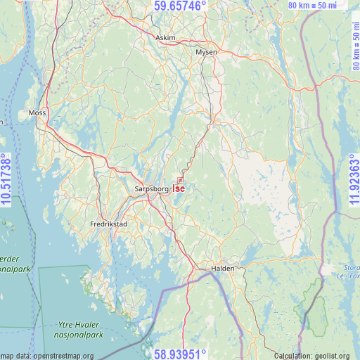
| Upper-left | 59.65746°, | 10.51738° |
| Center: | 59.30038°, | 11.2205° |
| Lower-right: | 58.93951°, | 11.92363° |
| Map W x H: | 79.8×79.8 km | = 49.6×49.6mi |
| max Lat: | 71.04137° ⇑83.4% North |
| Ise: | 59.30038° |
| min Lat: | ⇓16.6% South 58.0274° |
| min Long | Ise | max Long |
| 4.71485° | 11.2205° | 31.11066° |
| W 72.3%⇐ | ⇒27.7% E |
Elevation
Elevation of Ise is 49 m = 161 ft, and this is 55.2 m = 181 ft below average elevation for this country.
| Max E: |
897 m = 2943 ft | 47.8% |
| Avg. | 104.2 m = 342 ft | |
| Ise | 49 m = 161 ft | |
Min E: |
1 m = 3 ft | 52.2% |
See also: Norway elevation on elevation.city.
Geographical zone
Ise is located in North temperate zone (between Tropic of Cancer and the Arctic Circle). Distance of this North polar circle is 807.6 km =501.8 mi to North.| Distance of | km | miles | from Ise |
|---|---|---|---|
| North Pole | 3413.5 | 2121 | to North |
| Arctic Circle | 807.6 | 501.8 | to North |
| Tropic Cancer | 3987.7 | 2477.8 | to South |
| Equator | 6593.6 | 4097.1 | to South |


Nearby cities:
15 places around Ise: (largest is in red/bold)
• Fossby
28.6 km =17.8 mi,  107°
107°
• Fredrikstad
18.9 km =11.7 mi,  241°
241°
• Halden
21.7 km =13.5 mi,  154°
154°
• Karlshus
20.6 km =12.8 mi,  286°
286°
• Kirkebygda
29 km =18 mi,  317°
317°
• Larkollen
31.6 km =19.6 mi,  276°
276°
• Lervik
27.1 km =16.8 mi,  263°
263°
• Meieribyen
19.7 km =12.2 mi,  350°
350°
• Mysen
28.8 km =17.9 mi,  11°
11°
• Rakkestad
15.6 km =9.7 mi,  27°
27°
• Rygge
28 km =17.4 mi, 287°
• Ryggebyen
27.9 km =17.3 mi, 287°
• Sarpsborg
6.6 km =4.1 mi,  253°
253°
• Skjeberg
10 km =6.2 mi,  189°
189°
• Slevik
25.3 km =15.7 mi, 242°
Sources, notices
• [Note1] Compared only with cities in Norway existing in our database
• [Src1] Map data: © OpenStreetMap contributors (CC-BY-SA)
• [Src2] Other city data from geonames.org with taken over terms of usage.
• [Src3] Geographical zone / Annual Mean Temperature by Robert A. Rohde @ Wikipedia
