Ikornnes geodata
Ikornnes (Møre og Romsdal) is a populated place; located in Norway in Europe/Oslo (GMT+2) time zone. With population of 737 people, there are 370 cities with bigger population in this country. Compared to other cities in Norway, 66.9% of cities are located further ↓South; 78% of cities are located further →East and 100% of cities have higher elevation than Ikornnes. Note1


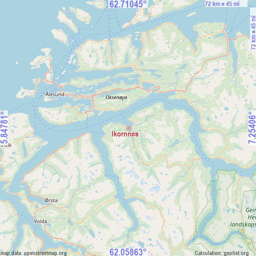
Ikornnes GPS coordinates[2]
62° 23' 10.716" North, 6° 33' 3.384" East
| Map corner | latitude | longitude |
|---|---|---|
| Upper-left | 62.71045°, | 5.84781° |
| Center: | 62.38631°, | 6.55094° |
| Lower-right: | 62.05863°, | 7.25406° |
| Map W x H: | 72.5×72.5 km | = 45×45mi |
| max Lat: | 71.04137° ⇑33.1% North |
| Ikornnes: | 62.38631° |
| min Lat: | ⇓66.9% South 58.0274° |
| min Long | Ikornnes | max Long |
| 4.71485° | 6.55094° | 31.11066° |
| W 22%⇐ | ⇒78% E |
Elevation
Elevation of Ikornnes is 1 m = 3 ft, and this is 103.2 m = 339 ft below average elevation for this country.
| Max E: |
897 m = 2943 ft | 100% |
| Avg. | 104.2 m = 342 ft | |
| Ikornnes | 1 m = 3 ft | |
Min E: |
1 m = 3 ft | 0% |
See also: Norway elevation on elevation.city.
Geographical zone
Ikornnes is located in North temperate zone (between Tropic of Cancer and the Arctic Circle). Distance of this North polar circle is 464.5 km =288.6 mi to North.| Distance of | km | miles | from Ikornnes |
|---|---|---|---|
| North Pole | 3070.4 | 1907.9 | to North |
| Arctic Circle | 464.5 | 288.6 | to North |
| Tropic Cancer | 4330.8 | 2691 | to South |
| Equator | 6936.7 | 4310.3 | to South |


Nearby cities:
15 places around Ikornnes: (largest is in red/bold)
• Brattvåg
24.4 km =15.2 mi,  347°
347°
• Giskemo
19.5 km =12.1 mi,  56°
56°
• Hareid
27 km =16.8 mi,  266°
266°
• Langevåg
19.5 km =12.1 mi,  288°
288°
• Nordstranda
25.8 km =16 mi,  303°
303°
• Sjøholt
17.3 km =10.7 mi,  51°
51°
• Skodje
15.1 km =9.4 mi,  29°
29°
• Stordal
22.4 km =13.9 mi,  91°
91°
• Stranda
21.7 km =13.5 mi,  113°
113°
• Sykkylven
2.2 km =1.4 mi, 60°
• Syvik
22.3 km =13.9 mi,  324°
324°
• Tomra
29.2 km =18.1 mi,  42°
42°
• Valderøy
24.9 km =15.5 mi, 300°
• Vatne
19.4 km =12.1 mi,  10°
10°
• Ålesund
22.5 km =14 mi, 295°
Sources, notices
• [Note1] Compared only with cities in Norway existing in our database
• [Src1] Map data: © OpenStreetMap contributors (CC-BY-SA)
• [Src2] Other city data from geonames.org with taken over terms of usage.
• [Src3] Geographical zone / Annual Mean Temperature by Robert A. Rohde @ Wikipedia
