Hareid geodata
Hareid (Møre og Romsdal) is a seat of a second-order administrative division; located in Norway in Europe/Oslo (GMT+2) time zone. With population of 3,626 people, there are 114 cities with bigger population in this country. Compared to other cities in Norway, 66.6% of cities are located further ↓South; 82.8% of cities are located further →East and 100% of cities have higher elevation than Hareid. Note1


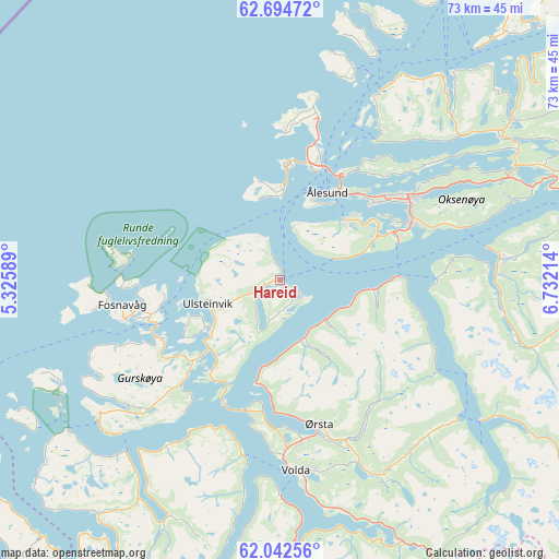
Hareid GPS coordinates[2]
62° 22' 13.476" North, 6° 1' 44.472" East
| Map corner | latitude | longitude |
|---|---|---|
| Upper-left | 62.69472°, | 5.32589° |
| Center: | 62.37041°, | 6.02902° |
| Lower-right: | 62.04256°, | 6.73214° |
| Map W x H: | 72.5×72.5 km | = 45×45mi |
| max Lat: | 71.04137° ⇑33.4% North |
| Hareid: | 62.37041° |
| min Lat: | ⇓66.6% South 58.0274° |
| min Long | Hareid | max Long |
| 4.71485° | 6.02902° | 31.11066° |
| W 17.2%⇐ | ⇒82.8% E |
Elevation
Elevation of Hareid is 1 m = 3 ft, and this is 103.2 m = 339 ft below average elevation for this country.
| Max E: |
897 m = 2943 ft | 100% |
| Avg. | 104.2 m = 342 ft | |
| Hareid | 1 m = 3 ft | |
Min E: |
1 m = 3 ft | 0% |
See also: Norway elevation on elevation.city.
Geographical zone
Hareid is located in North temperate zone (between Tropic of Cancer and the Arctic Circle). Distance of this North polar circle is 466.2 km =289.7 mi to North.| Distance of | km | miles | from Hareid |
|---|---|---|---|
| North Pole | 3072.1 | 1908.9 | to North |
| Arctic Circle | 466.2 | 289.7 | to North |
| Tropic Cancer | 4329 | 2689.9 | to South |
| Equator | 6934.9 | 4309.1 | to South |


Nearby cities:
15 places around Hareid: (largest is in red/bold)
• Brattvåg
33.3 km =20.7 mi,  39°
39°
• Fosnavåg
20.6 km =12.8 mi,  261°
261°
• Ikornnes
27 km =16.8 mi,  86°
86°
• Langevåg
11.5 km =7.1 mi,  46°
46°
• Larsnes
29.9 km =18.6 mi,  231°
231°
• Nordstranda
16.8 km =10.4 mi,  18°
18°
• Roald
24.1 km =15 mi,  11°
11°
• Sykkylven
28.9 km =18 mi,  84°
84°
• Syvik
24.3 km =15.1 mi,  34°
34°
• Ulsteinvik
9.8 km =6.1 mi,  251°
251°
• Ulsteinvik weather pws station
10 km =6.2 mi, 252°
• Valderøy
15.5 km =9.6 mi, 20°
• Volda
25 km =15.5 mi,  175°
175°
• Ålesund
13 km =8.1 mi, 29°
• Ørsta
19.7 km =12.2 mi,  164°
164°
Sources, notices
• [Note1] Compared only with cities in Norway existing in our database
• [Src1] Map data: © OpenStreetMap contributors (CC-BY-SA)
• [Src2] Other city data from geonames.org with taken over terms of usage.
• [Src3] Geographical zone / Annual Mean Temperature by Robert A. Rohde @ Wikipedia
