Sjøholt geodata
Sjøholt (Møre og Romsdal) is a seat of a second-order administrative division; located in Norway in Europe/Oslo (GMT+2) time zone. With population of 1,133 people, there are 289 cities with bigger population in this country. Compared to other cities in Norway, 67.7% of cities are located further ↓South; 75% of cities are located further →East and 58.2% of cities have higher elevation than Sjøholt. Note1


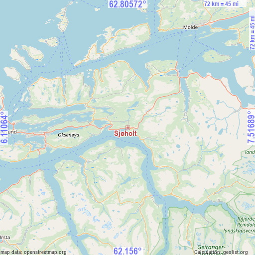
Sjøholt GPS coordinates[2]
62° 28' 57.468" North, 6° 48' 49.536" East
| Map corner | latitude | longitude |
|---|---|---|
| Upper-left | 62.80572°, | 6.11064° |
| Center: | 62.48263°, | 6.81376° |
| Lower-right: | 62.156°, | 7.51689° |
| Map W x H: | 72.2×72.2 km | = 44.9×44.9mi |
| max Lat: | 71.04137° ⇑32.3% North |
| Sjøholt: | 62.48263° |
| min Lat: | ⇓67.7% South 58.0274° |
| min Long | Sjøholt | max Long |
| 4.71485° | 6.81376° | 31.11066° |
| W 25%⇐ | ⇒75% E |
Elevation
Elevation of Sjøholt is 30 m = 98 ft, and this is 74.2 m = 243 ft below average elevation for this country.
| Max E: |
897 m = 2943 ft | 58.2% |
| Avg. | 104.2 m = 342 ft | |
| Sjøholt | 30 m = 98 ft | |
Min E: |
1 m = 3 ft | 41.8% |
See also: Norway elevation on elevation.city.
Geographical zone
Sjøholt is located in North temperate zone (between Tropic of Cancer and the Arctic Circle). Distance of this North polar circle is 453.8 km =282 mi to North.| Distance of | km | miles | from Sjøholt |
|---|---|---|---|
| North Pole | 3059.6 | 1901.1 | to North |
| Arctic Circle | 453.8 | 282 | to North |
| Tropic Cancer | 4341.5 | 2697.7 | to South |
| Equator | 6947.4 | 4316.9 | to South |


Nearby cities:
15 places around Sjøholt: (largest is in red/bold)
• Brattvåg
23 km =14.3 mi,  304°
304°
• Giskemo
2.7 km =1.7 mi,  88°
88°
• Ikornnes
17.3 km =10.7 mi,  231°
231°
• Langevåg
32.3 km =20.1 mi,  261°
261°
• Midsund
22.4 km =13.9 mi,  341°
341°
• Molde
33.4 km =20.8 mi,  31°
31°
• Skodje
6.7 km =4.2 mi,  291°
291°
• Stordal
14.3 km =8.9 mi,  141°
141°
• Stranda
20.4 km =12.7 mi,  161°
161°
• Sykkylven
15.1 km =9.4 mi, 230°
• Syvik
27.4 km =17 mi, 285°
• Tomra
12.5 km =7.8 mi, 28°
• Valldal
31 km =19.3 mi,  131°
131°
• Vatne
13.1 km =8.1 mi,  309°
309°
• Vestnes
21.2 km =13.2 mi,  41°
41°
Sources, notices
• [Note1] Compared only with cities in Norway existing in our database
• [Src1] Map data: © OpenStreetMap contributors (CC-BY-SA)
• [Src2] Other city data from geonames.org with taken over terms of usage.
• [Src3] Geographical zone / Annual Mean Temperature by Robert A. Rohde @ Wikipedia
