Blakstad geodata
Blakstad (Akershus) is a populated locality; located in Norway in Europe/Oslo (GMT+2) time zone. With population of 1,898 people, there are 210 cities with bigger population in this country. Compared to other cities in Norway, 69.3% of cities are located further ↑North; 57.8% of cities are located further ←West and 62.5% of cities have higher elevation than Blakstad. Note1


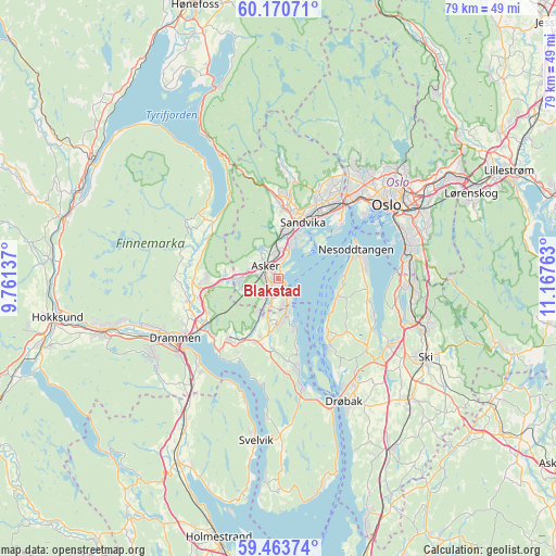
Blakstad GPS coordinates[2]
59° 49' 8.76" North, 10° 27' 52.2" East
| Map corner | latitude | longitude |
|---|---|---|
| Upper-left | 60.17071°, | 9.76137° |
| Center: | 59.8191°, | 10.4645° |
| Lower-right: | 59.46374°, | 11.16763° |
| Map W x H: | 78.6×78.6 km | = 48.8×48.8mi |
| max Lat: | 71.04137° ⇑69.3% North |
| Blakstad: | 59.8191° |
| min Lat: | ⇓30.7% South 58.0274° |
| min Long | Blakstad | max Long |
| 4.71485° | 10.4645° | 31.11066° |
| W 57.8%⇐ | ⇒42.2% E |
Elevation
Elevation of Blakstad is 25 m = 82 ft, and this is 79.2 m = 260 ft below average elevation for this country.
| Max E: |
897 m = 2943 ft | 62.5% |
| Avg. | 104.2 m = 342 ft | |
| Blakstad | 25 m = 82 ft | |
Min E: |
1 m = 3 ft | 37.5% |
See also: Norway elevation on elevation.city.
Geographical zone
Blakstad is located in North temperate zone (between Tropic of Cancer and the Arctic Circle). Distance of this North polar circle is 749.9 km =466 mi to North.| Distance of | km | miles | from Blakstad |
|---|---|---|---|
| North Pole | 3355.8 | 2085.2 | to North |
| Arctic Circle | 749.9 | 466 | to North |
| Tropic Cancer | 4045.3 | 2513.6 | to South |
| Equator | 6651.3 | 4132.9 | to South |


Nearby cities:
15 places around Blakstad: (largest is in red/bold)
• Asker
2.2 km =1.4 mi,  316°
316°
• Billingstad
6.3 km =3.9 mi,  9°
9°
• Fagerstrand
11.6 km =7.2 mi,  141°
141°
• Fjellstrand
8.4 km =5.2 mi,  109°
109°
• Lierbyen
12.8 km =8 mi,  253°
253°
• Lysaker
13.9 km =8.6 mi,  43°
43°
• Nesoddtangen
12.1 km =7.5 mi,  66°
66°
• Røyken
9.1 km =5.7 mi,  208°
208°
• Sandvika
8.7 km =5.4 mi,  23°
23°
• Skui
12.1 km =7.5 mi,  355°
355°
• Slemmestad
4.6 km =2.9 mi,  156°
156°
• Smestad
12.8 km =8 mi,  352°
352°
• Sylling
12.7 km =7.9 mi,  310°
310°
• Tranby
11.4 km =7.1 mi,  264°
264°
• Åros
12.8 km =8 mi,  168°
168°
Sources, notices
• [Note1] Compared only with cities in Norway existing in our database
• [Src1] Map data: © OpenStreetMap contributors (CC-BY-SA)
• [Src2] Other city data from geonames.org with taken over terms of usage.
• [Src3] Geographical zone / Annual Mean Temperature by Robert A. Rohde @ Wikipedia
