Lierbyen geodata
Lierbyen (Buskerud) is a seat of a second-order administrative division; located in Norway in Europe/Oslo (GMT+2) time zone. In our database, there are 488 cities with bigger population. Compared to other cities in Norway, 70.6% of cities are located further ↑North; 52.1% of cities are located further ←West and 63.3% of cities have higher elevation than Lierbyen. Note1


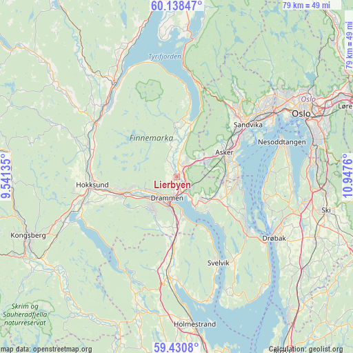
Lierbyen GPS coordinates[2]
59° 47' 11.436" North, 10° 14' 40.092" East
| Map corner | latitude | longitude |
|---|---|---|
| Upper-left | 60.13847°, | 9.54135° |
| Center: | 59.78651°, | 10.24447° |
| Lower-right: | 59.4308°, | 10.9476° |
| Map W x H: | 78.7×78.7 km | = 48.9×48.9mi |
| max Lat: | 71.04137° ⇑70.6% North |
| Lierbyen: | 59.78651° |
| min Lat: | ⇓29.4% South 58.0274° |
| min Long | Lierbyen | max Long |
| 4.71485° | 10.24447° | 31.11066° |
| W 52.1%⇐ | ⇒47.9% E |
Elevation
Elevation of Lierbyen is 24 m = 79 ft, and this is 80.2 m = 263 ft below average elevation for this country.
| Max E: |
897 m = 2943 ft | 63.3% |
| Avg. | 104.2 m = 342 ft | |
| Lierbyen | 24 m = 79 ft | |
Min E: |
1 m = 3 ft | 36.7% |
See also: Norway elevation on elevation.city.
Geographical zone
Lierbyen is located in North temperate zone (between Tropic of Cancer and the Arctic Circle). Distance of this North polar circle is 753.5 km =468.2 mi to North.| Distance of | km | miles | from Lierbyen |
|---|---|---|---|
| North Pole | 3359.4 | 2087.4 | to North |
| Arctic Circle | 753.5 | 468.2 | to North |
| Tropic Cancer | 4041.7 | 2511.4 | to South |
| Equator | 6647.6 | 4130.6 | to South |


Nearby cities:
15 places around Lierbyen: (largest is in red/bold)
• Asker
12 km =7.5 mi,  64°
64°
• Billingstad
16.6 km =10.3 mi,  53°
53°
• Blakstad
12.8 km =8 mi,  73°
73°
• Drammen
5.2 km =3.2 mi,  205°
205°
• Hokksund
18.8 km =11.7 mi,  264°
264°
• Mjøndalen
12.9 km =8 mi,  252°
252°
• Røyken
9.2 km =5.7 mi,  118°
118°
• Sandvika
19.6 km =12.2 mi, 53°
• Skoger
8.2 km =5.1 mi,  176°
176°
• Skui
19.3 km =12 mi,  35°
35°
• Slemmestad
14.1 km =8.8 mi,  92°
92°
• Smestad
19.4 km =12.1 mi,  32°
32°
• Sylling
12.1 km =7.5 mi,  12°
12°
• Tranby
2.6 km =1.6 mi,  20°
20°
• Åros
17.4 km =10.8 mi, 120°
Sources, notices
• [Note1] Compared only with cities in Norway existing in our database
• [Src1] Map data: © OpenStreetMap contributors (CC-BY-SA)
• [Src2] Other city data from geonames.org with taken over terms of usage.
• [Src3] Geographical zone / Annual Mean Temperature by Robert A. Rohde @ Wikipedia
