Sandvika geodata
Sandvika (Akershus) is a seat of a second-order administrative division; located in Norway in Europe/Oslo (GMT+2) time zone. In our database, there are 488 cities with bigger population. Compared to other cities in Norway, 67.9% of cities are located further ↑North; 59.3% of cities are located further ←West and 75.8% of cities have higher elevation than Sandvika. Note1


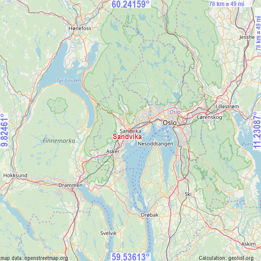
Sandvika GPS coordinates[2]
59° 53' 26.628" North, 10° 31' 39.864" East
| Map corner | latitude | longitude |
|---|---|---|
| Upper-left | 60.24159°, | 9.82461° |
| Center: | 59.89073°, | 10.52774° |
| Lower-right: | 59.53613°, | 11.23087° |
| Map W x H: | 78.4×78.4 km | = 48.7×48.7mi |
| max Lat: | 71.04137° ⇑67.9% North |
| Sandvika: | 59.89073° |
| min Lat: | ⇓32.1% South 58.0274° |
| min Long | Sandvika | max Long |
| 4.71485° | 10.52774° | 31.11066° |
| W 59.3%⇐ | ⇒40.7% E |
Elevation
Elevation of Sandvika is 13 m = 43 ft, and this is 91.2 m = 299 ft below average elevation for this country.
| Max E: |
897 m = 2943 ft | 75.8% |
| Avg. | 104.2 m = 342 ft | |
| Sandvika | 13 m = 43 ft | |
Min E: |
1 m = 3 ft | 24.2% |
See also: Norway elevation on elevation.city.
Geographical zone
Sandvika is located in North temperate zone (between Tropic of Cancer and the Arctic Circle). Distance of this North polar circle is 741.9 km =461 mi to North.| Distance of | km | miles | from Sandvika |
|---|---|---|---|
| North Pole | 3347.8 | 2080.2 | to North |
| Arctic Circle | 741.9 | 461 | to North |
| Tropic Cancer | 4053.3 | 2518.6 | to South |
| Equator | 6659.2 | 4137.8 | to South |


Nearby cities:
15 places around Sandvika: (largest is in red/bold)
• Asker
8.1 km =5 mi,  218°
218°
• Billingstad
3 km =1.9 mi,  236°
236°
• Blakstad
8.7 km =5.4 mi,  203°
203°
• Fagerstrand
17.4 km =10.8 mi,  167°
167°
• Fjellstrand
11.6 km =7.2 mi,  157°
157°
• Kolbotn
17.8 km =11.1 mi,  120°
120°
• Lysaker
6.4 km =4 mi,  70°
70°
• Nesoddtangen
8.2 km =5.1 mi,  112°
112°
• Oslo
12.4 km =7.7 mi,  78°
78°
• Sjølyststranda
9.1 km =5.7 mi, 68°
• Skui
6.1 km =3.8 mi,  312°
312°
• Slemmestad
12.3 km =7.6 mi,  187°
187°
• Smestad
7.1 km =4.4 mi, 311°
• Sylling
13.2 km =8.2 mi,  271°
271°
• Tranby
17.5 km =10.9 mi, 238°
Sources, notices
• [Note1] Compared only with cities in Norway existing in our database
• [Src1] Map data: © OpenStreetMap contributors (CC-BY-SA)
• [Src2] Other city data from geonames.org with taken over terms of usage.
• [Src3] Geographical zone / Annual Mean Temperature by Robert A. Rohde @ Wikipedia
