Botngård geodata
Botngård (Trøndelag) is a seat of a second-order administrative division; located in Norway in Europe/Oslo (GMT+2) time zone. With population of 1,144 people, there are 286 cities with bigger population in this country. Compared to other cities in Norway, 79% of cities are located further ↓South; 52.8% of cities are located further →East and 54.9% of cities have lower elevation than Botngård. Note1


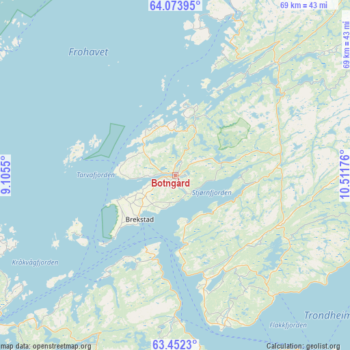
Botngård GPS coordinates[2]
63° 45' 53.424" North, 9° 48' 31.068" East
| Map corner | latitude | longitude |
|---|---|---|
| Upper-left | 64.07395°, | 9.1055° |
| Center: | 63.76484°, | 9.80863° |
| Lower-right: | 63.4523°, | 10.51176° |
| Map W x H: | 69.1×69.1 km | = 42.9×42.9mi |
| max Lat: | 71.04137° ⇑21% North |
| Botngård: | 63.76484° |
| min Lat: | ⇓79% South 58.0274° |
| min Long | Botngård | max Long |
| 4.71485° | 9.80863° | 31.11066° |
| W 47.2%⇐ | ⇒52.8% E |
Elevation
Elevation of Botngård is 60 m = 197 ft, and this is 44.2 m = 145 ft below average elevation for this country.
| Max E: |
897 m = 2943 ft | 45.1% |
| Avg. | 104.2 m = 342 ft | |
| Botngård | 60 m = 197 ft | |
Min E: |
1 m = 3 ft | 54.9% |
See also: Norway elevation on elevation.city.
Geographical zone
Botngård is located in North temperate zone (between Tropic of Cancer and the Arctic Circle). Distance of this North polar circle is 311.2 km =193.4 mi to North.| Distance of | km | miles | from Botngård |
|---|---|---|---|
| North Pole | 2917.1 | 1812.6 | to North |
| Arctic Circle | 311.2 | 193.4 | to North |
| Tropic Cancer | 4484.1 | 2786.3 | to South |
| Equator | 7090 | 4405.5 | to South |


Nearby cities:
15 places around Botngård: (largest is in red/bold)
• Brekstad
11.2 km =7 mi,  219°
219°
• Børsa
50.4 km =31.3 mi,  165°
165°
• Fillan
45 km =28 mi,  246°
246°
• Frosta
50 km =31.1 mi,  113°
113°
• Krokstadøra
43.2 km =26.8 mi,  200°
200°
• Leksvik
41.4 km =25.7 mi,  104°
104°
• Lensvik
27.9 km =17.3 mi,  180°
180°
• Malvik
56.8 km =35.3 mi,  130°
130°
• Orkanger
51 km =31.7 mi, 177°
• Rissa
21.5 km =13.4 mi,  159°
159°
• Roan
49.8 km =30.9 mi,  24°
24°
• Sistranda
48.2 km =30 mi,  264°
264°
• Trondheim
47.1 km =29.3 mi,  142°
142°
• Å i Åfjord
29.8 km =18.5 mi,  43°
43°
• Årnes
29.9 km =18.6 mi, 43°
Sources, notices
• [Note1] Compared only with cities in Norway existing in our database
• [Src1] Map data: © OpenStreetMap contributors (CC-BY-SA)
• [Src2] Other city data from geonames.org with taken over terms of usage.
• [Src3] Geographical zone / Annual Mean Temperature by Robert A. Rohde @ Wikipedia
