Krokstadøra geodata
Krokstadøra (Trøndelag) is a seat of a second-order administrative division; located in Norway in Europe/Oslo (GMT+2) time zone. In our database, there are 488 cities with bigger population. Compared to other cities in Norway, 75.9% of cities are located further ↓South; 56.2% of cities are located further →East and 62.5% of cities have lower elevation than Krokstadøra. Note1


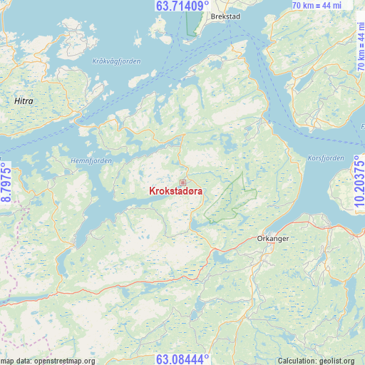
Krokstadøra GPS coordinates[2]
63° 24' 3.564" North, 9° 30' 2.232" East
| Map corner | latitude | longitude |
|---|---|---|
| Upper-left | 63.71409°, | 8.7975° |
| Center: | 63.40099°, | 9.50062° |
| Lower-right: | 63.08444°, | 10.20375° |
| Map W x H: | 70×70 km | = 43.5×43.5mi |
| max Lat: | 71.04137° ⇑24.1% North |
| Krokstadøra: | 63.40099° |
| min Lat: | ⇓75.9% South 58.0274° |
| min Long | Krokstadøra | max Long |
| 4.71485° | 9.50062° | 31.11066° |
| W 43.8%⇐ | ⇒56.2% E |
Elevation
Elevation of Krokstadøra is 80 m = 262 ft, and this is 24.2 m = 79 ft below average elevation for this country.
| Max E: |
897 m = 2943 ft | 37.5% |
| Avg. | 104.2 m = 342 ft | |
| Krokstadøra | 80 m = 262 ft | |
Min E: |
1 m = 3 ft | 62.5% |
See also: Norway elevation on elevation.city.
Geographical zone
Krokstadøra is located in North temperate zone (between Tropic of Cancer and the Arctic Circle). Distance of this North polar circle is 351.6 km =218.5 mi to North.| Distance of | km | miles | from Krokstadøra |
|---|---|---|---|
| North Pole | 2957.5 | 1837.7 | to North |
| Arctic Circle | 351.6 | 218.5 | to North |
| Tropic Cancer | 4443.6 | 2761.1 | to South |
| Equator | 7049.5 | 4380.4 | to South |


Nearby cities:
15 places around Krokstadøra: (largest is in red/bold)
• Botngård
43.2 km =26.8 mi,  20°
20°
• Brekstad
32.8 km =20.4 mi,  14°
14°
• Børsa
29.5 km =18.3 mi,  106°
106°
• Fillan
34.9 km =21.7 mi,  310°
310°
• Kyrksæterøra
23.9 km =14.9 mi,  239°
239°
• Lensvik
19.7 km =12.2 mi,  50°
50°
• Lundamo
48 km =29.8 mi,  125°
125°
• Løkken Verk
32.3 km =20.1 mi,  161°
161°
• Meldal
40.8 km =25.4 mi, 164°
• Melhus
40.9 km =25.4 mi, 108°
• Orkanger
20.3 km =12.6 mi,  121°
121°
• Rindal
41.1 km =25.5 mi,  200°
200°
• Rissa
30.5 km =19 mi, 48°
• Skaun
32.2 km =20 mi, 121°
• Trondheim
44.6 km =27.7 mi,  85°
85°
Sources, notices
• [Note1] Compared only with cities in Norway existing in our database
• [Src1] Map data: © OpenStreetMap contributors (CC-BY-SA)
• [Src2] Other city data from geonames.org with taken over terms of usage.
• [Src3] Geographical zone / Annual Mean Temperature by Robert A. Rohde @ Wikipedia
