Waiuku geodata
Waiuku (Auckland) is a populated place; located in New Zealand in Pacific/Auckland (GMT+12) time zone. With population of 7,555 people, there are 46 cities with bigger population in this country. Compared to other cities in New Zealand, 76.3% of cities are located further ↓South; 54.1% of cities are located further ←West and 75.8% of cities have higher elevation than Waiuku. Note1


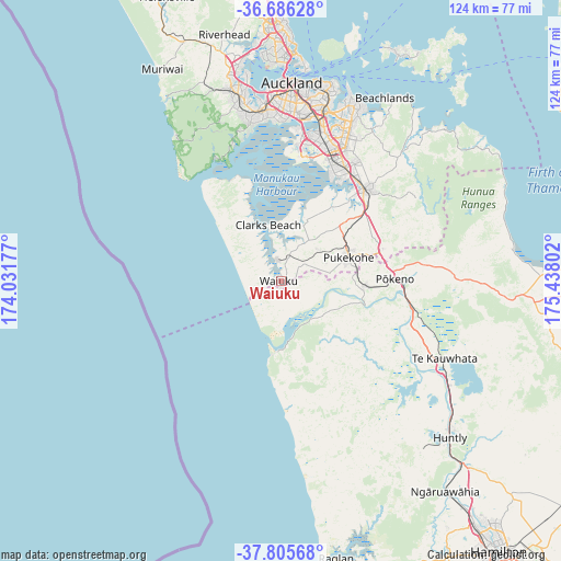
Waiuku GPS coordinates[2]
37° 14' 53.016" South, 174° 44' 5.604" East
| Map corner | latitude | longitude |
|---|---|---|
| Upper-left | -36.68628°, | 174.03177° |
| Center: | -37.24806°, | 174.73489° |
| Lower-right: | -37.80568°, | 175.43802° |
| Map W x H: | 124.5×124.5 km | = 77.4×77.4mi |
| max Lat: | -34.99604° ⇑23.7% North |
| Waiuku: | -37.24806° |
| min Lat: | ⇓76.3% South -46.6° |
| min Long | Waiuku | max Long |
| -176.55973° | 174.73489° | 178.33333° |
| W 54.1%⇐ | ⇒45.9% E |
Elevation
Elevation of Waiuku is 13 m = 43 ft, and this is 71.4 m = 234 ft below average elevation for this country.
| Max E: |
819 m = 2687 ft | 75.8% |
| Avg. | 84.4 m = 277 ft | |
| Waiuku | 13 m = 43 ft | |
Min E: |
3 m = 10 ft | 24.2% |
See also: New Zealand elevation on elevation.city.
Geographical zone
Waiuku is located in South temperate zone (between Tropic of Capricorn and the Antarctic Circle). Distance of this Southern Tropic circle is 1535.7 km =954.2 mi to North.| Distance of | km | miles | from Waiuku |
|---|---|---|---|
| Equator | 4141.6 | 2573.5 | to North |
| Tropic Capricorn | 1535.7 | 954.2 | to North |
| Antarctic Circle | 3259.6 | 2025.4 | to South |
| South Pole | 5865.5 | 3644.7 | to South |


Nearby cities:
15 places around Waiuku: (largest is in red/bold)
• Bombay
23.8 km =14.8 mi,  67°
67°
• East Tamaki
36.2 km =22.5 mi,  23°
23°
• Mangere
31.6 km =19.6 mi,  10°
10°
• Manukau City
31.2 km =19.4 mi, 24°
• Pakuranga
43.6 km =27.1 mi, 21°
• Papakura
27.5 km =17.1 mi,  42°
42°
• Pukekohe East
19.8 km =12.3 mi, 74°
• Red Hill
29.7 km =18.5 mi, 44°
• Rosebank
41.9 km =26 mi,  352°
352°
• Takanini
26.6 km =16.5 mi,  33°
33°
• Tamaki
41.5 km =25.8 mi, 15°
• Te Kauwhata
40.4 km =25.1 mi,  114°
114°
• Titirangi
35.2 km =21.9 mi, 348°
• Waitakere
37.4 km =23.2 mi, 349°
• Wiri
29.9 km =18.6 mi, 21°
Sources, notices
• [Note1] Compared only with cities in New Zealand existing in our database
• [Src1] Map data: © OpenStreetMap contributors (CC-BY-SA)
• [Src2] Other city data from geonames.org with taken over terms of usage.
• [Src3] Geographical zone / Annual Mean Temperature by Robert A. Rohde @ Wikipedia
