Mangere geodata
Mangere (Auckland) is a populated place; located in New Zealand in Pacific/Auckland (GMT+13) time zone. With population of 55,266 people, there are 15 cities with bigger population in this country. Compared to other cities in New Zealand, 82.1% of cities are located further ↓South; 58.9% of cities are located further ←West and 71% of cities have higher elevation than Mangere. Note1


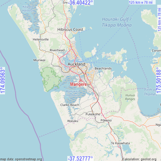
Mangere GPS coordinates[2]
36° 58' 5.052" South, 174° 47' 55.5" East
| Map corner | latitude | longitude |
|---|---|---|
| Upper-left | -36.40422°, | 174.09563° |
| Center: | -36.96807°, | 174.79875° |
| Lower-right: | -37.52777°, | 175.50188° |
| Map W x H: | 124.9×124.9 km | = 77.6×77.6mi |
| max Lat: | -34.99604° ⇑17.9% North |
| Mangere: | -36.96807° |
| min Lat: | ⇓82.1% South -46.6° |
| min Long | Mangere | max Long |
| -176.55973° | 174.79875° | 178.33333° |
| W 58.9%⇐ | ⇒41.1% E |
Elevation
Elevation of Mangere is 15 m = 49 ft, and this is 69.4 m = 228 ft below average elevation for this country.
| Max E: |
819 m = 2687 ft | 71% |
| Avg. | 84.4 m = 277 ft | |
| Mangere | 15 m = 49 ft | |
Min E: |
3 m = 10 ft | 29% |
See also: Mangere elevation on elevation.city.
Geographical zone
Mangere is located in South temperate zone (between Tropic of Capricorn and the Antarctic Circle). Distance of this Southern Tropic circle is 1504.5 km =934.9 mi to North.| Distance of | km | miles | from Mangere |
|---|---|---|---|
| Equator | 4110.5 | 2554.1 | to North |
| Tropic Capricorn | 1504.5 | 934.9 | to North |
| Antarctic Circle | 3290.7 | 2044.7 | to South |
| South Pole | 5896.6 | 3664 | to South |


Nearby cities:
15 places around Mangere: (largest is in red/bold)
• Auckland
13.7 km =8.5 mi,  346°
346°
• East Tamaki
9.2 km =5.7 mi,  77°
77°
• Manukau City
7.7 km =4.8 mi,  110°
110°
• Murrays Bay
27 km =16.8 mi, 350°
• North Shore
19.2 km =11.9 mi, 346°
• Pakuranga
14.1 km =8.8 mi,  48°
48°
• Papakura
16.9 km =10.5 mi,  130°
130°
• Red Hill
18.2 km =11.3 mi,  123°
123°
• Rosebank
15.4 km =9.6 mi,  312°
312°
• Rothesay Bay
27.4 km =17 mi, 349°
• Takanini
12.7 km =7.9 mi, 134°
• Tamaki
10.4 km =6.5 mi,  31°
31°
• Titirangi
13.1 km =8.1 mi,  284°
284°
• Waitakere
13.7 km =8.5 mi,  294°
294°
• Wiri
6.4 km =4 mi, 121°
Sources, notices
• [Note1] Compared only with cities in New Zealand existing in our database
• [Src1] Map data: © OpenStreetMap contributors (CC-BY-SA)
• [Src2] Other city data from geonames.org with taken over terms of usage.
• [Src3] Geographical zone / Annual Mean Temperature by Robert A. Rohde @ Wikipedia
