Methven geodata
Methven (Canterbury) is a populated place; located in New Zealand in Pacific/Auckland (GMT+13) time zone. With population of 1,236 people, there are 127 cities with bigger population in this country. Compared to other cities in New Zealand, 80.2% of cities are located further ↑North; 81.2% of cities are located further →East and 94.2% of cities have lower elevation than Methven. Note1


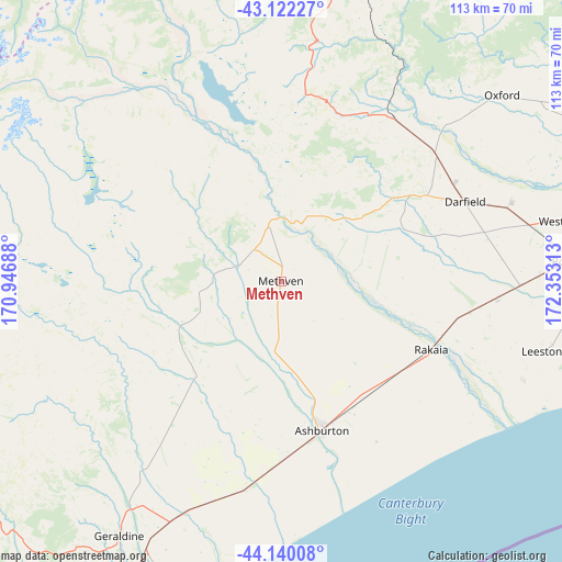
Methven GPS coordinates[2]
43° 37' 59.988" South, 171° 39' 0" East
| Map corner | latitude | longitude |
|---|---|---|
| Upper-left | -43.12227°, | 170.94688° |
| Center: | -43.63333°, | 171.65° |
| Lower-right: | -44.14008°, | 172.35313° |
| Map W x H: | 113.2×113.2 km | = 70.3×70.3mi |
| max Lat: | -34.99604° ⇑80.2% North |
| Methven: | -43.63333° |
| min Lat: | ⇓19.8% South -46.6° |
| min Long | Methven | max Long |
| -176.55973° | 171.65° | 178.33333° |
| W 18.8%⇐ | ⇒81.2% E |
Elevation
Elevation of Methven is 319 m = 1047 ft, and this is 234.6 m = 770 ft above average elevation for this country.
| Max E: |
819 m = 2687 ft | 5.8% |
| Methven | 319 m 1047 ft | |
| Avg. | 84.4 m = 277 ft | |
Min E: |
3 m = 10 ft | 94.2% |
See also: New Zealand elevation on elevation.city.
Geographical zone
Methven is located in South temperate zone (between Tropic of Capricorn and the Antarctic Circle). Distance of this Southern Tropic circle is 2245.7 km =1395.4 mi to North.| Distance of | km | miles | from Methven |
|---|---|---|---|
| Equator | 4851.6 | 3014.6 | to North |
| Tropic Capricorn | 2245.7 | 1395.4 | to North |
| Antarctic Circle | 2549.6 | 1584.2 | to South |
| South Pole | 5155.5 | 3203.5 | to South |


Nearby cities:
15 places around Methven: (largest is in red/bold)
• Arthur’s Pass
76.3 km =47.4 mi,  354°
354°
• Ashburton
30.2 km =18.8 mi,  167°
167°
• Burnham
53.7 km =33.4 mi,  88°
88°
• Christchurch
80 km =49.7 mi,  82°
82°
• Darfield
41.1 km =25.5 mi,  66°
66°
• Geraldine
60.3 km =37.5 mi,  212°
212°
• Leeston
54.3 km =33.7 mi,  105°
105°
• Lincoln
67.1 km =41.7 mi, 91°
• Oxford
56.8 km =35.3 mi,  49°
49°
• Pleasant Point
81.7 km =50.8 mi, 210°
• Prebbleton
70 km =43.5 mi, 85°
• Rakaia
32.2 km =20 mi, 113°
• Rolleston
59.3 km =36.8 mi, 84°
• Southbridge
52.3 km =32.5 mi, 112°
• Tinwald
32 km =19.9 mi, 170°
Sources, notices
• [Note1] Compared only with cities in New Zealand existing in our database
• [Src1] Map data: © OpenStreetMap contributors (CC-BY-SA)
• [Src2] Other city data from geonames.org with taken over terms of usage.
• [Src3] Geographical zone / Annual Mean Temperature by Robert A. Rohde @ Wikipedia
